IMAGES TAKEN NEAR TO
Coulsdon Road, COULSDON, CR5 1EB
Introduction
This page details the photographs taken nearby to Coulsdon Road, CR5 1EB by members of the Geograph project.
The Geograph project started in 2005 with the aim of publishing, organising and preserving representative images for every square kilometre of Great Britain, Ireland and the Isle of Man.

There are currently over 7.5m images from over14,400 individuals and you can help contribute to the project by visiting https://www.geograph.org.uk
Image Map (Loading...)


Getting Data...Please wait
Leaflet Map data © OpenStreetMap
Images are licensed for reuse under creativecommons.org/licenses/by-sa/2.0
Notes
- Clicking on the map will re-center to the selected point.
- The higher the marker number, the further away the image location is from the centre of the postcode.
Image Listing (87 Images Found)
Images are licensed for reuse under creativecommons.org/licenses/by-sa/2.0
Image
Details
Distance
1
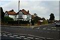
Junction of Keston Avenue and Coulsdon Road
Road junction near the centre of Old Coulsdon, Surrey.
Image: © Peter Trimming
Taken: 7 Nov 2012
0.07 miles
2
The Tudor Rose. Old Coulsdon, Surrey
This well-known landmark has served for many years as a bus terminus, currently for Route 60 from Streatham.
Image: © Dr Neil Clifton
Taken: 20 Sep 2005
0.10 miles
3
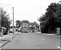
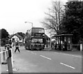
Old Coulsdon (Tudor Rose) bus terminus
For many years, London Transport as well as its predecessors and its new constituents, has liked to identify its termini by the use of the name of a public house. The inn here has a long tradition in this respect, (the actual pub. is out of view to the right). The bus stand is actually in Placehouse Lane: it is a very well used terminus, as not only is there the public house, (whose more conscientious drinkers surely use the bus), but there is a very large college just adjoining and an important medical centre, with eight doctors working, (visible behind the bus, but rebuilt as a two-story building since this photograph).
In 1983 the route that terminated here was the 190, as shown, which ran to Thornton Heath.
Image: © Dr Neil Clifton
Taken: 12 Jun 1983
0.11 miles
4
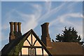
Tudor Rose Public House, Old Coulsdon
The Tudor Rose is a mock Elizabethan building with these wonderful 'barley sugar' chimney pots.
Image: © Keith Brewster
Taken: 17 Jul 2006
0.11 miles
5
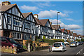
Court Avenue
1930s housing in Court Avenue. The road is marked on the 1935 1:2,500 map, with some development shown.
Image: © Ian Capper
Taken: 27 Oct 2018
0.11 miles
6
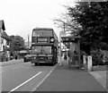
Old Coulsdon (Tudor Rose) bus terminus
In 1998, this was the terminus of Route 50, which used Olympian double deckers, as shown here. The bus is standing in Place House Lane, and the Tudor Rose pub. is out of shot to the right.
Image: © Dr Neil Clifton
Taken: 25 Aug 1998
0.12 miles
7
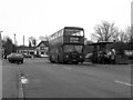
Old Coulsdon bus terminus
A Leyland Olympian on Route 190 at the Tudor Rose, Old Coulsdon, its northern terminus. This has now become a very busy place as a large college adjoins, but in this photograph, only a few pensioners seem to be waiting.
Image: © Dr Neil Clifton
Taken: 31 Mar 1988
0.12 miles
8

John Brown
Rear view of John Brown estates agency office
Image: © Kurseong Carl
Taken: 29 May 2011
0.12 miles
9
Old Coulsdon (Tudor Rose) bus terminus
The use of the 'Tudor Rose' at Old Coulsdon as a bus terminus dates from the early days of motor buses in London. For many years it was the southern terminus of Route 190 from Thornton Heath High Street, but about 1970 Route 50 took over. Here is Leyland Olympian L52 as seen in 1998, but more recently Route 60 serves this terminus instead.
Image: © Dr Neil Clifton
Taken: 25 Aug 1998
0.12 miles
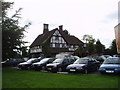
10

Old Coulsdon, Surrey: Court Avenue
As usual, both sides of Court Avenue are occupied by parked cars, whose drivers are probably attending the large medical centre at the end of the road on the right. The single-storey building on the left was formerly a Coal Office, but is now occupied by an estate agent. In the distance is seen the Tudor Parade, (of shops).
Image: © Dr Neil Clifton
Taken: 27 Mar 2012
0.12 miles