IMAGES TAKEN NEAR TO
Chaldon Way, COULSDON, CR5 1DJ
Introduction
This page details the photographs taken nearby to Chaldon Way, CR5 1DJ by members of the Geograph project.
The Geograph project started in 2005 with the aim of publishing, organising and preserving representative images for every square kilometre of Great Britain, Ireland and the Isle of Man.

There are currently over 7.5m images from over14,400 individuals and you can help contribute to the project by visiting https://www.geograph.org.uk
Image Map (Loading...)


Getting Data...Please wait
Leaflet Map data © OpenStreetMap
Images are licensed for reuse under creativecommons.org/licenses/by-sa/2.0
Notes
- Clicking on the map will re-center to the selected point.
- The higher the marker number, the further away the image location is from the centre of the postcode.
Image Listing (32 Images Found)
Images are licensed for reuse under creativecommons.org/licenses/by-sa/2.0
Image
Details
Distance
1
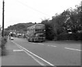
Chaldon Way, Coulsdon
A quiet suburban road served by Route 50 buses.
Image: © Dr Neil Clifton
Taken: 25 Aug 1998
0.11 miles
2
View From Downs Road, Coulsdon, Surrey
Looking up the road towards Farthing Downs. I'm standing on the gridline, and the left half of the photograph is in this gridsquare.
Image: © Peter Trimming
Taken: 4 Jul 2009
0.12 miles
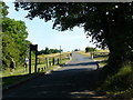
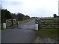
4
Ditches Lane
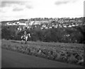
Descending the northern end of Farthing Downs towards Coulsdon. On a clearer day you could see features such as the Crystal Palace mast and Canary Wharf.
Image: © Bill Boaden
Taken: 18 May 2019
0.15 miles
5
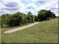
Footpath
This footpath on Farthing Downs runs through an area of many tumuli.
Image: © Hywel Williams
Taken: 11 Jul 2005
0.16 miles
6
Path down to Coulsdon
Coming off the northern end of Farthing Downs.
Image: © Bill Boaden
Taken: 18 May 2019
0.18 miles
7
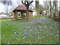
Crocuses and shelter in Chaldon Way Gardens
Chaldon Way Gardens was given to the Urban District Council by the developer, Fairdean Heights Ltd, who built the surrounding houses during the 1930s. The Company also allowed the Council to collect and use free of charge "such earth, turf, sub-soil, flowers and shrubs as can be removed from the Company's Fairdean Heights Estate" to create the Gardens. The ornamental garden were constructed with lawns, shrub beds and annual bedding displays, and a small shelter at one end of the garden. The shelter can be seen here along with a display of crocuses. Chaldon Way Gardens are in the angle formed by Marlpit Lane and Chaldon Way.
Image: © Marathon
Taken: 27 Mar 2013
0.18 miles
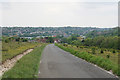
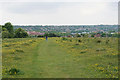
8
The way onto Farthing Downs
Farthing Downs is a fine chalk grassland, owned and managed by the Corporation of London. From the highest parts there are good views northwards towards London, as well as down into the valley to the west followed by the Brighton Road and main railway line. The London LOOP follows the crest of the Downs, parallel to Ditches Lane, before dropping down to reach Coulsdon. This view looks up the hill along Ditches Lane as it heads to the Downs.
Image: © Marathon
Taken: 27 Mar 2013
0.18 miles
9
View from Farthing Downs, Coulsdon, Surrey
Image: © Dr Neil Clifton
Taken: 26 Dec 1977
0.18 miles
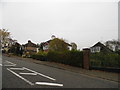
10
Mead Way
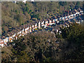
Typical inter-war suburban housing, as seen from Farthing Downs.
Image: © Stephen Richards
Taken: 21 Jan 2017
0.19 miles