IMAGES TAKEN NEAR TO
Upper Court Road, CATERHAM, CR3 7BF
Introduction
This page details the photographs taken nearby to Upper Court Road, CR3 7BF by members of the Geograph project.
The Geograph project started in 2005 with the aim of publishing, organising and preserving representative images for every square kilometre of Great Britain, Ireland and the Isle of Man.

There are currently over 7.5m images from over14,400 individuals and you can help contribute to the project by visiting https://www.geograph.org.uk
Image Map (Loading...)


Getting Data...Please wait
Leaflet Map data © OpenStreetMap
Images are licensed for reuse under creativecommons.org/licenses/by-sa/2.0
Notes
- Clicking on the map will re-center to the selected point.
- The higher the marker number, the further away the image location is from the centre of the postcode.
Image Listing (25 Images Found)
Images are licensed for reuse under creativecommons.org/licenses/by-sa/2.0
Image
Details
Distance
1
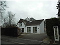
House on Northdown Road, Woldingham
It's hard to tell if this is an older house with new windows or the whole house is modern. Besides the fancy windows on the side it could be any age in the 20th century as the design is a classic shape.
Image: © David Howard
Taken: 11 Jan 2015
0.13 miles
2
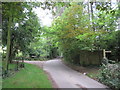
Path junction on Southfields Road
Southfields road is an unadopted road leading (past various houses) from Slines Oak Road towards The Ridge.
A footpath leads right to Upper Court Road.
A bridleway leads left along Southview Road to The Ridge.
Image: © David Anstiss
Taken: 6 Sep 2014
0.16 miles
3
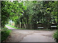
Southfields Road meets Upper Court Road
Southfields Road leads from Slines Oak Road. Upper Court Road leads right to Northdown Road, or left towards The Ridge.
Image: © David Anstiss
Taken: 6 Sep 2014
0.16 miles
4
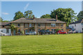
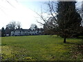
Woldingham village green
The village green in Woldingham. In the background are Tea Tree Cottages.
Image: © Ian Capper
Taken: 5 Jun 2014
0.18 miles
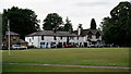
6
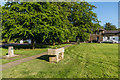
The Green at Woldingham
This attractive little green is on the west side of Station Road and south of Park View Road.
Ian Nairn in 'The Buildings of England: Surrey' describes Woldingham: "This tiny downland hamlet SE of Caterham has gradually become a very leafy suburb. The parish is full of steep-sided valleys and the houses are hidden away in these, usually drowned in trees - an object lesson to the brutally expanded Warlingham, next door."
Image: © Marathon
Taken: 2 Mar 2023
0.19 miles
7
The Green at Woldingham
This attractive little green is on the west side of Station Road and south of Park View Road.
Ian Nairn in 'The Buildings of England: Surrey' describes Woldingham: "This tiny downland hamlet SE of Caterham has gradually become a very leafy suburb. The parish is full of steep-sided valleys and the houses are hidden away in these, usually drowned in trees - an object lesson to the brutally expanded Warlingham, next door."
Image: © Marathon
Taken: 2 Mar 2023
0.19 miles
8

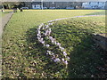
Drinking fountain, Woldingham Village Green
Drinking fountain on Woldingham Village Green. The plaque reads "Metropolitan Drinking Fountain and Cattle Trough Association 70 Victoria Street London SW1". For wider view see Image
Image: © Ian Capper
Taken: 5 Jun 2014
0.19 miles
9
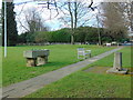
Woldingham Village Green
Cattle trough and drinking fountain on Woldingham Village Green. The cattle trough is inscribed "Erected by the inhabitants of Woldingham August 1907".
For close up of the drinking fountain on the left see Image
Image: © Ian Capper
Taken: 5 Jun 2014
0.19 miles
10
Woldingham
The Green, seen from the end of Station Road.
Image: © Peter Trimming
Taken: 4 Jul 2017
0.19 miles