IMAGES TAKEN NEAR TO
Tupwood Scrubbs Road, Tupwood Lane, CATERHAM, CR3 6TH
Introduction
This page details the photographs taken nearby to Tupwood Scrubbs Road, Tupwood Lane, CR3 6TH by members of the Geograph project.
The Geograph project started in 2005 with the aim of publishing, organising and preserving representative images for every square kilometre of Great Britain, Ireland and the Isle of Man.

There are currently over 7.5m images from over14,400 individuals and you can help contribute to the project by visiting https://www.geograph.org.uk
Image Map (Loading...)


Getting Data...Please wait
Leaflet Map data © OpenStreetMap
Images are licensed for reuse under creativecommons.org/licenses/by-sa/2.0
Notes
- Clicking on the map will re-center to the selected point.
- The higher the marker number, the further away the image location is from the centre of the postcode.
Image Listing (51 Images Found)
Images are licensed for reuse under creativecommons.org/licenses/by-sa/2.0
Image
Details
Distance
1
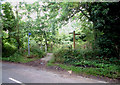
North Downs Way near A22
Tupwood Lane is in the foreground. To the left, the path leads eastwards across the footbridge depicted in the view of the A22 at this point.
Image: © Philip Talmage
Taken: 27 Aug 2005
0.05 miles
2

Fenced-in footpath
An enclosed path through the trees, named Fosterdown Wood on "Streetmap".
Image: © Andrew Hill
Taken: 17 Nov 2009
0.07 miles
3
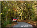
Driving through the trees
A van heads towards Caterham along Tupwood Scrubbs Road.
Image: © Andrew Hill
Taken: 17 Nov 2009
0.09 miles
4
Hidden entrance to a house on Tupwood Scrubs Road
The house is entirely surrounded by the trees and invisible from the road.
Image: © David Howard
Taken: 17 Nov 2013
0.11 miles
5
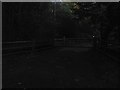
A corner of Tupwood Scrubbs Road
A little lane deep among trees with driveways leading away.
Image: © Andrew Hill
Taken: 17 Nov 2009
0.11 miles
6
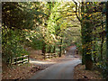
Woods by Tupwood Scrubs Road, Caterham
Image: © David Howard
Taken: 17 Nov 2013
0.12 miles
7

Pilgrim Fort WD boundary stone no. 5
By the North Downs Way, the fort is now in private hands.
Image: © Robin Webster
Taken: 2 Jul 2019
0.12 miles
8

North Downs Way, Gravelly Hill
Looking west towards an open viewpoint area by the road.
Image: © Robin Webster
Taken: 2 Jul 2019
0.12 miles
9

Pilgrim Fort WD boundary stone no. 4
The fort on the top of the hill is now in private hands.
Image: © Robin Webster
Taken: 2 Jul 2019
0.12 miles
10

North Downs Way below Pilgrim Fort
A small open area with a seat and, on the extreme left, one of the WD boundary stones for the fort area, now in private hands.
Image: © Robin Webster
Taken: 2 Jul 2019
0.13 miles