IMAGES TAKEN NEAR TO
Rogers Close, CATERHAM, CR3 6QW
Introduction
This page details the photographs taken nearby to Rogers Close, CR3 6QW by members of the Geograph project.
The Geograph project started in 2005 with the aim of publishing, organising and preserving representative images for every square kilometre of Great Britain, Ireland and the Isle of Man.

There are currently over 7.5m images from over14,400 individuals and you can help contribute to the project by visiting https://www.geograph.org.uk
Image Map (Loading...)


Getting Data...Please wait
Leaflet Map data © OpenStreetMap
Images are licensed for reuse under creativecommons.org/licenses/by-sa/2.0
Notes
- Clicking on the map will re-center to the selected point.
- The higher the marker number, the further away the image location is from the centre of the postcode.
Image Listing (20 Images Found)
Images are licensed for reuse under creativecommons.org/licenses/by-sa/2.0
Image
Details
Distance
1
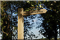
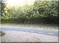
Public Bridleway Sign
A new sign, at the top of Tillingdown Hill.
Image: © Peter Trimming
Taken: 20 Oct 2015
0.05 miles
2
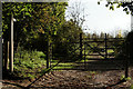
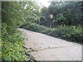
Public Bridleway
Seen at the top of Tillingdown Hill; the bridleway leads to Tillingdown Farm, a further half mile up the hill.
Image: © Peter Trimming
Taken: 20 Oct 2015
0.06 miles
3
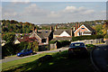
View From Caterham
Looking from Tillingdown Hill, towards Warlingham. Near the skyline, to the left of picture, the scar of the former chalk pit at Riddlesdown can be seen.
Image: © Peter Trimming
Taken: 20 Oct 2015
0.07 miles
9

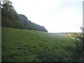
View From Caterham
The location is close to the Caterham Bypass, with the view towards Warlingham.
Image: © Peter Trimming
Taken: 20 Oct 2015
0.21 miles
10
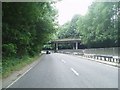
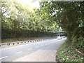
The Caterham Bypass
This Bypass road dates from the 1930s. It was entirely dual carriageway until recent years when one lane on the northern route was closed. This was a road safety measure following several serious accidents.
Image: © Nigel Freeman
Taken: 3 Jul 2005
0.21 miles