IMAGES TAKEN NEAR TO
Stafford Road, CATERHAM, CR3 6JG
Introduction
This page details the photographs taken nearby to Stafford Road, CR3 6JG by members of the Geograph project.
The Geograph project started in 2005 with the aim of publishing, organising and preserving representative images for every square kilometre of Great Britain, Ireland and the Isle of Man.

There are currently over 7.5m images from over14,400 individuals and you can help contribute to the project by visiting https://www.geograph.org.uk
Image Map
Images are licensed for reuse under creativecommons.org/licenses/by-sa/2.0
Notes
- Clicking on the map will re-center to the selected point.
- The higher the marker number, the further away the image location is from the centre of the postcode.
Image Listing (187 Images Found)
Images are licensed for reuse under creativecommons.org/licenses/by-sa/2.0
Image
Details
Distance
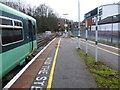
1
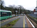
Caterham station
The first proposals for a railway along the Caterham Valley came in 1836 with the object of building a new London to Dover line through a mile long tunnel under the North Downs. It proved too costly and the existing line via Redhill was used. Instead Caterham received a branch line, built by a private company in 1856. The original purpose was to provide a convenient method of transporting the valuable building stone from the quarries at Godstone to London. Soon though the original purpose was overtaken by wealthy Victorian commuters using the line as the Caterham Valley developed. There were early frustrations for these commuters, for example, in the London, Brighton & South Coast Railway arranging for the connecting train at Godstone Road (now Purley) station to leave one minute before the Caterham train arrived. In this photograph a Southern train awaits the start of its journey from the terminus at Caterham to London Bridge. The wooded nature of the Caterham Valley can be clearly seen beyond the platform.
Image: © Marathon
Taken: 25 Jan 2012
0.03 miles
2
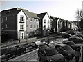
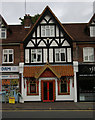
Pegasus Court
Retirement apartments in Stafford Road, Caterham Valley
Image: © Rib
Taken: 6 Jan 2009
0.03 miles
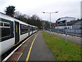
3
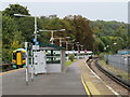
Train leaving Caterham station
An electric multiple unit (EMU) leaving Caterham station. Caterham is the terminus at the end of a branch line. The railway is electrified using the third rail system.
Image: © Malc McDonald
Taken: 12 Oct 2019
0.04 miles
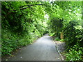
4
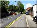
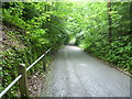
Caterham: Stafford Road
Seen from its south end. This mile-long road parallels the railway on the west side and reaches a T-junction with Burntwood Lane very near the Wapses Lodge roundabout.
Image: © Dr Neil Clifton
Taken: 21 Apr 2011
0.05 miles
5
Train awaiting departure at Caterham
The first proposals for a railway along the Caterham Valley came in 1836 with the object of building a new London to Dover line through a mile long tunnel under the North Downs. It proved too costly and the existing line via Redhill was used. Instead Caterham received a branch line, built by a private company in 1856. The original purpose was to provide a convenient method of transporting the valuable building stone from the quarries at Godstone to London. Soon though the original purpose was overtaken by wealthy Victorian commuters using the line as the Caterham Valley developed. There were early frustrations for these commuters, for example, in the London, Brighton & South Coast Railway arranging for the connecting train at Godstone Road (now Purley) station to leave one minute before the Caterham train arrived. In this photograph a Southern train awaits the start of its journey from the terminus at Caterham to London Bridge.
Image: © Marathon
Taken: 25 Jan 2012
0.06 miles
6
Waller Lane, Caterham
Waller Lane leads steeply uphill along the side of Caterham Valley from lower Caterham near the station and East Surrey Museum to upper Caterham at the High Street. In the whole time I walked up it not a single car passed, although the roads at the bottom and top were busy.
Image: © Marathon
Taken: 4 Jul 2012
0.06 miles
7
Trains at Caterham
The first proposals for a railway along the Caterham Valley came in 1836 with the object of building a new London to Dover line through a mile long tunnel under the North Downs. It proved too costly and the existing line via Redhill was used. Instead Caterham received a branch line, built by a private company in 1856. The original purpose was to provide a convenient method of transporting the valuable building stone from the quarries at Godstone to London. Soon though the original purpose was overtaken by wealthy Victorian commuters using the line as the Caterham Valley developed. There were early frustrations for these commuters, for example, in the London, Brighton & South Coast Railway arranging for the connecting train at Godstone Road (now Purley) station to leave one minute before the Caterham train arrived. In this photograph a Southern train awaits the start of its journey from the terminus at Caterham to London Bridge, whilst in the distance another train has just left.
Image: © Marathon
Taken: 25 Jan 2012
0.06 miles
8
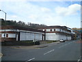
Former Rose and Young Car Showroom, Caterham
Image: © Stacey Harris
Taken: 11 Apr 2010
0.06 miles
10
Waller Lane, Caterham
Waller Lane leads steeply uphill along the side of Caterham Valley from lower Caterham near the station and East Surrey Museum to upper Caterham at the High Street. In the whole time I walked up it not a single car passed, although the roads at the bottom and top were busy.
Image: © Marathon
Taken: 4 Jul 2012
0.08 miles