IMAGES TAKEN NEAR TO
Tupwood Lane, CATERHAM, CR3 6ET
Introduction
This page details the photographs taken nearby to Tupwood Lane, CR3 6ET by members of the Geograph project.
The Geograph project started in 2005 with the aim of publishing, organising and preserving representative images for every square kilometre of Great Britain, Ireland and the Isle of Man.

There are currently over 7.5m images from over14,400 individuals and you can help contribute to the project by visiting https://www.geograph.org.uk
Image Map (Loading...)


Getting Data...Please wait
Leaflet Map data © OpenStreetMap
Images are licensed for reuse under creativecommons.org/licenses/by-sa/2.0
Notes
- Clicking on the map will re-center to the selected point.
- The higher the marker number, the further away the image location is from the centre of the postcode.
Image Listing (27 Images Found)
Images are licensed for reuse under creativecommons.org/licenses/by-sa/2.0
Image
Details
Distance
1

The entrance to The Mardens on Tupwood Lane
Image: © David Howard
Taken: 17 Nov 2013
0.08 miles
3
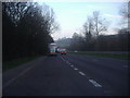
A22 at Caterham
Going south and nearing access to the southern M25 London orbital motorway
Image: © Nigel Freeman
Taken: 3 Jul 2005
0.15 miles
4
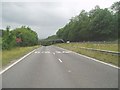
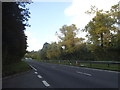
Godstone Road
The view north from the lay-by along the A22 road near the M25.
Image: © Gordon Griffiths
Taken: 11 May 2018
0.15 miles


8
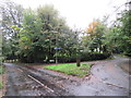
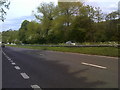
Road junction near Caterham
A junction of minor roads on the North Downs, near Caterham. The blue signs attached to the lamp post indicate the route of National Cycle Network route 21.
Image: © Malc McDonald
Taken: 12 Oct 2019
0.18 miles
10
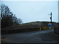
No longer The Downs residential site
The mobile home park has just been demolished, it was still there in 2012
Image: © David Howard
Taken: 17 Nov 2013
0.19 miles