IMAGES TAKEN NEAR TO
Aldercombe Lane, CATERHAM, CR3 6ED
Introduction
This page details the photographs taken nearby to Aldercombe Lane, CR3 6ED by members of the Geograph project.
The Geograph project started in 2005 with the aim of publishing, organising and preserving representative images for every square kilometre of Great Britain, Ireland and the Isle of Man.

There are currently over 7.5m images from over14,400 individuals and you can help contribute to the project by visiting https://www.geograph.org.uk
Image Map
Images are licensed for reuse under creativecommons.org/licenses/by-sa/2.0
Notes
- Clicking on the map will re-center to the selected point.
- The higher the marker number, the further away the image location is from the centre of the postcode.
Image Listing (8 Images Found)
Images are licensed for reuse under creativecommons.org/licenses/by-sa/2.0
Image
Details
Distance
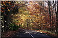
1
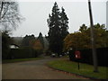
Dome Hill at the junction of Aldercombe Lane and Dome Hill Peak
Image: © David Howard
Taken: 17 Nov 2013
0.06 miles
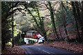
4
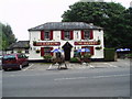
A country pub in Surrey
Popular with walkers on the adjoining Pilgrims Way. Several fine real ales served and also food.
Image: © Dr Neil Clifton
Taken: 28 Sep 2005
0.23 miles
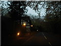
5
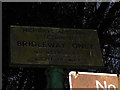
Bridleway sign at the end of Dome Hill
Although made since 1980 (as it is dated) it may have replaced an earlier one as copied the pre 1964 style, including using pressed metal lettering.
Image: © David Howard
Taken: 17 Nov 2013
0.23 miles
7
Caterham
Weald Way, which drops down to Harestone Valley Road.
Image: © Peter Trimming
Taken: 17 Nov 2017
0.24 miles
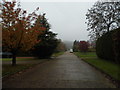
8
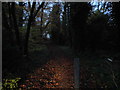
Bridleway between Dome Hill and Woodland Way
Possibly the shortest bridle way in Britain, at around 100 yards long.
Image: © David Howard
Taken: 17 Nov 2013
0.25 miles