IMAGES TAKEN NEAR TO
Ninehams Close, CATERHAM, CR3 5LQ
Introduction
This page details the photographs taken nearby to Ninehams Close, CR3 5LQ by members of the Geograph project.
The Geograph project started in 2005 with the aim of publishing, organising and preserving representative images for every square kilometre of Great Britain, Ireland and the Isle of Man.

There are currently over 7.5m images from over14,400 individuals and you can help contribute to the project by visiting https://www.geograph.org.uk
Image Map (Loading...)


Getting Data...Please wait
Leaflet Map data © OpenStreetMap
Images are licensed for reuse under creativecommons.org/licenses/by-sa/2.0
Notes
- Clicking on the map will re-center to the selected point.
- The higher the marker number, the further away the image location is from the centre of the postcode.
Image Listing (29 Images Found)
Images are licensed for reuse under creativecommons.org/licenses/by-sa/2.0
Image
Details
Distance
1
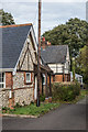
The Keeper's Cottage and Ninehams Lodge
Late Victorian cottages on a side road off Ninehams Road.
Image: © Ian Capper
Taken: 12 Oct 2018
0.08 miles
3
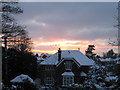
Sunset over Buxton Lane
Beautiful sunset on 7 January 2010.
Image: © Peter Heather
Taken: 7 Jan 2010
0.09 miles
4
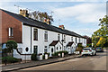
135 - 147 Buxton Lane
Late Victorian terrace, marked on the 1897 1:2,500 map as Coulsdon Cottages.
Image: © Ian Capper
Taken: 12 Oct 2018
0.10 miles
5

Merlewood Estate Office
Estate office for the West Wickham and Coulsdon group of commons, which together with Ashtead Common make up 7 areas of open spaces in south London and Surrey owned by the City of London Corporation and known collectively as the City Commons. For a close up of the coat of arms above the door, see Image
Image: © Ian Capper
Taken: 12 Oct 2018
0.10 miles
6

City of London Corporation coat of arms
Coat of arms of the City of London Corporation on the wall above the entrance to Merlewood Estate Office - see Image
Image: © Ian Capper
Taken: 12 Oct 2018
0.10 miles
7
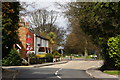
Buxton Lane, Kenley, Surrey
Around the bend, to the left, Buxton Lane becomes Hayes Lane. Straight on, is the bridleway to Kenley Common.
Image: © Peter Trimming
Taken: 1 Apr 2010
0.10 miles
8
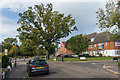
Buxton Lane
Buxton Lane near its junction with Halton Road and Egan Close, and just before it becomes Hayes Lane. The current route of Hayes Lane is off to the left; prior to the building of RAF Kenley in WWII, its route was straight on from here.
Image: © Ian Capper
Taken: 12 Oct 2018
0.12 miles
9
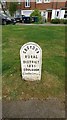
Old Boundary Marker
Parish Boundary Marker on the north side of the junction of Fenemore Road and Halton Road, Croydon. In raised lettering CROYDON / RURAL / DISTRICT / 1895 / COULSDON. See also https://www.geograph.org.uk/photo/5952975.
Milestone Society National ID: SY_CROY07pb
Image: © R Mills
Taken: 13 May 2020
0.12 miles
10
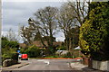
Road Junction on Buxton Lane, Kenley, Surrey
The Royal Mail van continues on Buxton Lane, towards Kenley airfield. Salmons Lane West comes in from the right. Ninehams Road is hidden, to the left.
Image: © Peter Trimming
Taken: 1 Apr 2010
0.13 miles