IMAGES TAKEN NEAR TO
Ninehams Road, CATERHAM, CR3 5LN
Introduction
This page details the photographs taken nearby to Ninehams Road, CR3 5LN by members of the Geograph project.
The Geograph project started in 2005 with the aim of publishing, organising and preserving representative images for every square kilometre of Great Britain, Ireland and the Isle of Man.

There are currently over 7.5m images from over14,400 individuals and you can help contribute to the project by visiting https://www.geograph.org.uk
Image Map (Loading...)


Getting Data...Please wait
Leaflet Map data © OpenStreetMap
Images are licensed for reuse under creativecommons.org/licenses/by-sa/2.0
Notes
- Clicking on the map will re-center to the selected point.
- The higher the marker number, the further away the image location is from the centre of the postcode.
Image Listing (25 Images Found)
Images are licensed for reuse under creativecommons.org/licenses/by-sa/2.0
Image
Details
Distance
1
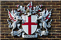
City of London Corporation coat of arms
Coat of arms of the City of London Corporation on the wall above the entrance to Merlewood Estate Office - see Image
Image: © Ian Capper
Taken: 12 Oct 2018
0.04 miles
2

Merlewood Estate Office
Estate office for the West Wickham and Coulsdon group of commons, which together with Ashtead Common make up 7 areas of open spaces in south London and Surrey owned by the City of London Corporation and known collectively as the City Commons. For a close up of the coat of arms above the door, see Image
Image: © Ian Capper
Taken: 12 Oct 2018
0.05 miles
3
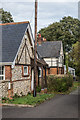
The Keeper's Cottage and Ninehams Lodge
Late Victorian cottages on a side road off Ninehams Road.
Image: © Ian Capper
Taken: 12 Oct 2018
0.08 miles
4
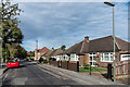
Addison Road
c1960s bungalows in Addison Road.
Image: © Ian Capper
Taken: 12 Oct 2018
0.08 miles
5

Spencer Road
Housing on a 1950s extension of Spencer Road on what the 1935 1:2,500 map mark as allotment gardens.
Image: © Ian Capper
Taken: 12 Oct 2018
0.12 miles
6
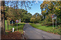
Stites Hill Road
Stites Hill Road as it enters Coulsdon Common. On the left is a coal tax post (no 168 on the list linked to below) - see Image for a close up.
Image: © Ian Capper
Taken: 27 Oct 2018
0.12 miles
7
Coal tax post no 168
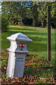
This coal tax post (no 168 on the list linked to below) is situated alongside Stites Hill Road as it enters Coulsdon Common. See Image for a wider view.
Image: © Ian Capper
Taken: 27 Oct 2018
0.12 miles
8
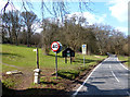
First Signs of London
This is leaving Surrey and coming into London, although it doesn't look like it.
This is Coulsdon Common, an amenity area of countryside maintained by the City of London. That's their smart black sign. The houses begin just round the corner.
The little bollard nearest the camera is a Coal Tax Post. There's another one about 5 minutes walk up the path on the left. I know because I've just put in a picture of it.
Funny, you can go your whole life without ever meeting a Coal Tax Post and then two come along at once. I've even got the Wiki. link still saved http://en.wikipedia.org/wiki/Coal-tax_post
Image: © Des Blenkinsopp
Taken: 2 Apr 2013
0.13 miles
9

Addison Road
Housing in Addison Road dating from various periods of the 20th Century.
Image: © Ian Capper
Taken: 12 Oct 2018
0.13 miles
10
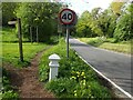
Coulsdon Common
Coulsdon Common is owned and managed by the City of London Corporation along with a number of other properties in the south of the Borough of Croydon. It is largely wooded. This view looks along Stites Hill Road with a City of London boundary post in the foreground - see http://www.coaldutyposts.org.uk/cityposts.html
Image: © Marathon
Taken: 4 May 2023
0.14 miles