IMAGES TAKEN NEAR TO
Whyteleafe Road, CATERHAM, CR3 5EJ
Introduction
This page details the photographs taken nearby to Whyteleafe Road, CR3 5EJ by members of the Geograph project.
The Geograph project started in 2005 with the aim of publishing, organising and preserving representative images for every square kilometre of Great Britain, Ireland and the Isle of Man.

There are currently over 7.5m images from over14,400 individuals and you can help contribute to the project by visiting https://www.geograph.org.uk
Image Map (Loading...)


Getting Data...Please wait
Leaflet Map data © OpenStreetMap
Images are licensed for reuse under creativecommons.org/licenses/by-sa/2.0
Notes
- Clicking on the map will re-center to the selected point.
- The higher the marker number, the further away the image location is from the centre of the postcode.
Image Listing (7 Images Found)
Images are licensed for reuse under creativecommons.org/licenses/by-sa/2.0
Image
Details
Distance
1
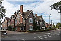
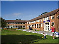
Buxton Lodge Care Home
Care home in Buxton Lane, housed in a large house built in 1871 originally called Greenlands.
Image: © Ian Capper
Taken: 12 Oct 2018
0.13 miles
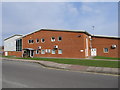
3
De Stafford College, Caterham, Surrey
A comprehensive school of Surrey Education Authority
Image: © Dr Neil Clifton
Taken: 24 Sep 2005
0.16 miles
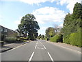
4
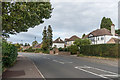
Buxton Lane
c1930s housing in Buxton Lane. Older maps name the road Buxton's Lane, and show a large house further along the lane called The Buckstones.
Image: © Ian Capper
Taken: 12 Oct 2018
0.17 miles
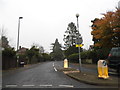
5
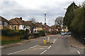
Buxton Lane, Kenley, Surrey
Looking in the direction of Kenley airfield. Once a quiet lane, now quite a busy road with a bus service.
Image: © Peter Trimming
Taken: 1 Apr 2010
0.20 miles