
IMAGES TAKEN NEAR TO
Pilgrims Lane, CATERHAM, CR3 5DX
Introduction
This page details the photographs taken nearby to Pilgrims Lane, CR3 5DX by members of the Geograph project.
The Geograph project started in 2005 with the aim of publishing, organising and preserving representative images for every square kilometre of Great Britain, Ireland and the Isle of Man.

There are currently over 7.5m images from over14,400 individuals and you can help contribute to the project by visiting https://www.geograph.org.uk
Image Map
Images are licensed for reuse under creativecommons.org/licenses/by-sa/2.0
Notes
- Clicking on the map will re-center to the selected point.
- The higher the marker number, the further away the image location is from the centre of the postcode.
Image Listing (24 Images Found)
Images are licensed for reuse under creativecommons.org/licenses/by-sa/2.0
Image
Details
Distance
1

Willey Park Farm
See from the path across White Down.
Image: © Ian Capper
Taken: 5 May 2008
0.02 miles
2

Building at Willey Park Farm
This curious building sits at the entrance to Willey Park Farm. It looks as if it has been made vaguely habitable. The North Downs Way runs along Pilgrims Lane behind.
Image: © Ian Capper
Taken: 5 May 2008
0.05 miles
3

Willey Park Farm
An old out-building which stands beside the North Downs Way.
Image: © Peter Trimming
Taken: 26 Oct 2022
0.05 miles
4

Willey Park Farm
A view taken from Stanstead Road
Image: © Kurseong Carl
Taken: 13 May 2011
0.05 miles
5

North Downs Way on Pilgrim's Lane
The long distance path follows a farm track (bridleway) past Willey Park Farm towards Hill Top Farm.
A footpath leads left through the farm towards Quarry Hangers, on the North Downs.
Image: © David Anstiss
Taken: 16 May 2012
0.05 miles
6
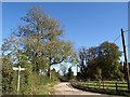
Pilgrims' Lane at Willey Park Farm
The North Downs Way and the Pilgrims' Way follow bridleway 10 along Pilgrims' Lane here. The right turn is footpath 14, to Quarry Hangers. Part of the farmhouse is on the right behind the telegraph pole.
Image: © Derek Harper
Taken: 15 Oct 2011
0.06 miles
7

Willey Park Farm
A view of the farm from the North Downs way off Stanstead Road
Image: © Kurseong Carl
Taken: 13 May 2011
0.07 miles
8

North Downs Way near Willey Park Farm
The long distance path heads along Pilgrim's Lane (bridleway) past the farm and various horse paddocks towards Hill Top Farm.
This section of the farm track is now a very muddy track...
Image: © David Anstiss
Taken: 16 May 2012
0.10 miles
9

North Downs Way at Willey Farm Lane
The long distance path heads left along Pilgrim's Lane (bridleway) towards Willey Farm. It also heads right along an unnamed farm track (bridleway) towards White Hill.
Another bridleway heads right along Willey Farm Lane towards Chaldon.
There are great views of the City of London from here. The Shard, Gherkin and various other buildings can be seen.
Image: © David Anstiss
Taken: 16 May 2012
0.10 miles
10

Willey Farm Lane
From the junction at which Pilgrim's Lane becomes Willey Farm Lane, and a very similar view to Image The lane carries bridleway 10. The North Downs Way turns right at this point, heading for the edge of the scarp. Ahead is housing at Chaldon.
Image: © Derek Harper
Taken: 15 Oct 2011
0.12 miles