IMAGES TAKEN NEAR TO
Riding Hill, SOUTH CROYDON, CR2 9LP
Introduction
This page details the photographs taken nearby to Riding Hill, CR2 9LP by members of the Geograph project.
The Geograph project started in 2005 with the aim of publishing, organising and preserving representative images for every square kilometre of Great Britain, Ireland and the Isle of Man.

There are currently over 7.5m images from over14,400 individuals and you can help contribute to the project by visiting https://www.geograph.org.uk
Image Map (Loading...)


Getting Data...Please wait
Leaflet Map data © OpenStreetMap
Images are licensed for reuse under creativecommons.org/licenses/by-sa/2.0
Notes
- Clicking on the map will re-center to the selected point.
- The higher the marker number, the further away the image location is from the centre of the postcode.
Image Listing (27 Images Found)
Images are licensed for reuse under creativecommons.org/licenses/by-sa/2.0
Image
Details
Distance
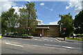
1
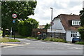
The Catholic Church of The Holy Family, Sanderstead
On Limpsfield Road.
Image: © David Anstiss
Taken: 13 Nov 2011
0.09 miles
2
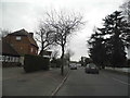
Car park behind Waitrose, Sanderstead
Image: © Christopher Hilton
Taken: 30 Jun 2013
0.09 miles
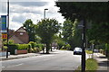
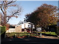
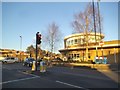
6
Limpsfield Road, Sanderstead
The church hall of the Catholic Church of the Holy Family is on the left
Image: © David Howard
Taken: 11 Jan 2015
0.10 miles
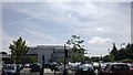
7
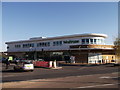
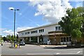
Waitrose Supermarket, Sanderstead
On Limpsfield Road.
Image: © David Anstiss
Taken: 13 Nov 2011
0.10 miles
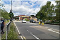
8
Waitrose Lights
The view of Waitrose Supermarket Sanderstead on Limpsfield Road.
Image: © Gordon Griffiths
Taken: 15 Jan 2016
0.10 miles