IMAGES TAKEN NEAR TO
Drury Lane, HALSTEAD, CO9 4SL
Introduction
This page details the photographs taken nearby to Drury Lane, CO9 4SL by members of the Geograph project.
The Geograph project started in 2005 with the aim of publishing, organising and preserving representative images for every square kilometre of Great Britain, Ireland and the Isle of Man.

There are currently over 7.5m images from over14,400 individuals and you can help contribute to the project by visiting https://www.geograph.org.uk
Image Map
Images are licensed for reuse under creativecommons.org/licenses/by-sa/2.0
Notes
- Clicking on the map will re-center to the selected point.
- The higher the marker number, the further away the image location is from the centre of the postcode.
Image Listing (46 Images Found)
Images are licensed for reuse under creativecommons.org/licenses/by-sa/2.0
Image
Details
Distance
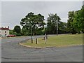
1
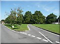
Short cut across the green, Ridgewell
Single track, but no sign of tyre marks on the grass!
Image: © Humphrey Bolton
Taken: 24 Jul 2008
0.03 miles
2
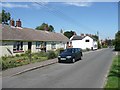
Houses, Drury Lane, Ridgewell
The bungalows look like as if they might have been built for old people by the former Rural District Council.
Image: © Humphrey Bolton
Taken: 24 Jul 2008
0.03 miles
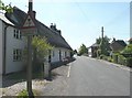
3
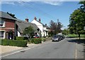
Houses, Drury Lane, Ridgewell
This is where Drury Lane meets The Green. The thatched cottage is timber-framed, although built as two cottages in the early 19C. See http://www.imagesofengland.org.uk/Details/Default.aspx?id=114130&mode=adv for more details and a clearer view.
Image: © Humphrey Bolton
Taken: 24 Jul 2008
0.03 miles
4
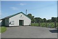
The Coronation Village Hall, Ridgewell
This was built to commemorate the 1953 coronation, and extended and modernised to mark the Millennium. The recreation ground is behind the fence and gate.
Image: © Humphrey Bolton
Taken: 24 Jul 2008
0.05 miles
5
Overhanging roof, Drury Lane, Ridgewell
An unusual road sign that seems no longer necessary now that there is a hedge in line with the edge of the roof.
Image: © Humphrey Bolton
Taken: 24 Jul 2008
0.05 miles
6
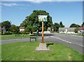
The village sign, The Green, Ridgewell
There seems to be a tradition around here for attractive village signs on the green, rather than on the approach roads.
Image: © Humphrey Bolton
Taken: 24 Jul 2008
0.10 miles
7
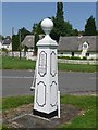
The village pump, The Green, Ridgewell
Made by Ransomes of Ipswich in the 19C. If they hadn't put an extra R in 'erected' they wouldn't have run out of space!
Image: © Humphrey Bolton
Taken: 24 Jul 2008
0.10 miles
8
Richmond House, The Green, Ridgewell
According to the English Heritage listing this 18C house is timber-framed, the structure hidden behind the plastered walls. See http://www.imagesofengland.org.uk/Details/Default.aspx?id=114138&mode=adv.
Image: © Humphrey Bolton
Taken: 24 Jul 2008
0.10 miles
9
Ridgewell Sign
The view of the village sign off Drury Lane, Essex.
Image: © Gordon Griffiths
Taken: 19 Jul 2019
0.11 miles
10

War Memorial, The Green, Ridgewell
The lions on the corner posts are a nice feature.
Image: © Humphrey Bolton
Taken: 24 Jul 2008
0.13 miles