IMAGES TAKEN NEAR TO
Birdbrook Road, HALSTEAD, CO9 4PA
Introduction
This page details the photographs taken nearby to Birdbrook Road, CO9 4PA by members of the Geograph project.
The Geograph project started in 2005 with the aim of publishing, organising and preserving representative images for every square kilometre of Great Britain, Ireland and the Isle of Man.

There are currently over 7.5m images from over14,400 individuals and you can help contribute to the project by visiting https://www.geograph.org.uk
Image Map
Images are licensed for reuse under creativecommons.org/licenses/by-sa/2.0
Notes
- Clicking on the map will re-center to the selected point.
- The higher the marker number, the further away the image location is from the centre of the postcode.
Image Listing (9 Images Found)
Images are licensed for reuse under creativecommons.org/licenses/by-sa/2.0
Image
Details
Distance
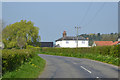
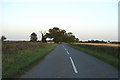
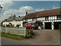
3
Birdbrook Road
Looking north west towards Warren Farm -
Image]
Image: © JThomas
Taken: 20 May 2017
0.01 miles
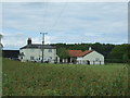
4
House near Chapelend way
Looking W.N.W. in early evening light
Image: © Robert Walden
Taken: 11 Sep 2007
0.03 miles
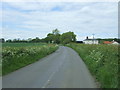
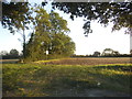
5
Road to Chapelend Way
Looking E.S.E. early evening. A large house is on the left by the trees.
Image: © Robert Walden
Taken: 11 Sep 2007
0.05 miles
6
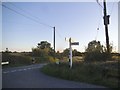
Birdbrook Road at the junction of Cornish Hall End Road
Image: © David Howard
Taken: 27 Aug 2017
0.19 miles
7
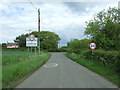
Entering Stambourne
Looking north east on Cornish Hall End Road.
Image: © JThomas
Taken: 20 May 2017
0.20 miles
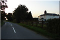
9
Cottages at Stambourne Green, Essex
Stambourne Green is a part of the village of Stambourne, which is quite a sprawling village in north Essex.
Image: © Robert Edwards
Taken: 5 May 2006
0.23 miles