IMAGES TAKEN NEAR TO
Finchingfield Road, HALSTEAD, CO9 4NH
Introduction
This page details the photographs taken nearby to Finchingfield Road, CO9 4NH by members of the Geograph project.
The Geograph project started in 2005 with the aim of publishing, organising and preserving representative images for every square kilometre of Great Britain, Ireland and the Isle of Man.

There are currently over 7.5m images from over14,400 individuals and you can help contribute to the project by visiting https://www.geograph.org.uk
Image Map
Images are licensed for reuse under creativecommons.org/licenses/by-sa/2.0
Notes
- Clicking on the map will re-center to the selected point.
- The higher the marker number, the further away the image location is from the centre of the postcode.
Image Listing (6 Images Found)
Images are licensed for reuse under creativecommons.org/licenses/by-sa/2.0
Image
Details
Distance
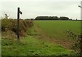
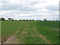
1
Footpath to Stambourne Green
Leaving Finchingfield Road at Craig's End.
Image: © Robin Webster
Taken: 8 Apr 2017
0.04 miles
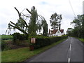
2
Farm buildings on Finchingfield Road, Robin Hood End
Image: © David Howard
Taken: 22 Sep 2024
0.10 miles
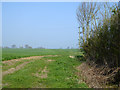
4
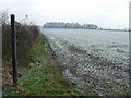
Public Footpath
Public footpath near to Robinhood End, Essex.
Image: © Keith Evans
Taken: 13 Dec 2012
0.14 miles