IMAGES TAKEN NEAR TO
Toppesfield, HALSTEAD, CO9 4EB
Introduction
This page details the photographs taken nearby to CO9 4EB by members of the Geograph project.
The Geograph project started in 2005 with the aim of publishing, organising and preserving representative images for every square kilometre of Great Britain, Ireland and the Isle of Man.

There are currently over 7.5m images from over14,400 individuals and you can help contribute to the project by visiting https://www.geograph.org.uk
Image Map
Images are licensed for reuse under creativecommons.org/licenses/by-sa/2.0
Notes
- Clicking on the map will re-center to the selected point.
- The higher the marker number, the further away the image location is from the centre of the postcode.
Image Listing (11 Images Found)
Images are licensed for reuse under creativecommons.org/licenses/by-sa/2.0
Image
Details
Distance
1
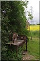
Old Saw and Power Pylon
This old table saw is long past its heyday but pylons and Oil Seed Rape seem to dominate the countryside these days
Image: © Glyn Baker
Taken: 24 May 2015
0.01 miles
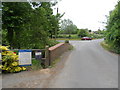
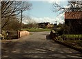
3
Green Road Junction
Road junction near to Toppesfield, Essex.
Image: © Keith Evans
Taken: 13 Apr 2009
0.04 miles
4
Weak bridge over River Colne
Limited to 3 T weight and 6' 6" wide at the moment, hopefully not for ever.
Image: © Robin Webster
Taken: 17 Apr 2017
0.04 miles
5
Stream at Cust Hall
Looking upstream from the road bridge
Image: © Glyn Baker
Taken: 24 May 2015
0.05 miles
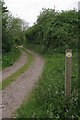
6
Little bridge south of Toppesfield, Essex
Image: © Robert Edwards
Taken: 14 Apr 2006
0.09 miles
7
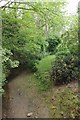
Footpath Nearing Cust Hall
This is the approach road to Image
Image: © Glyn Baker
Taken: 24 May 2015
0.14 miles
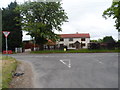
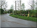
9
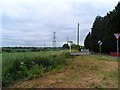
Junction,farm land and pylons near to Toppesfield
Image: © Bikeboy
Taken: 9 Jun 2013
0.22 miles
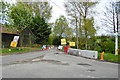
10
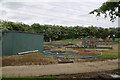
Sewage Works Near Toppesfield
This facility is operated by Anglian Water
Image: © Glyn Baker
Taken: 24 May 2015
0.23 miles