IMAGES TAKEN NEAR TO
Morris Green, HALSTEAD, CO9 3LS
Introduction
This page details the photographs taken nearby to Morris Green, CO9 3LS by members of the Geograph project.
The Geograph project started in 2005 with the aim of publishing, organising and preserving representative images for every square kilometre of Great Britain, Ireland and the Isle of Man.

There are currently over 7.5m images from over14,400 individuals and you can help contribute to the project by visiting https://www.geograph.org.uk
Image Map
Images are licensed for reuse under creativecommons.org/licenses/by-sa/2.0
Notes
- Clicking on the map will re-center to the selected point.
- The higher the marker number, the further away the image location is from the centre of the postcode.
Image Listing (11 Images Found)
Images are licensed for reuse under creativecommons.org/licenses/by-sa/2.0
Image
Details
Distance
1
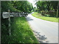
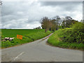
Road Junction Sign
Road junction direction sign near to Delvin End, Essex.
Image: © Keith Evans
Taken: 25 May 2017
0.03 miles
2
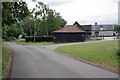
Sugar Lane at Bird's Green Farm
Looking towards Image
Image: © Glyn Baker
Taken: 5 Jun 2020
0.05 miles
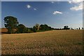
3
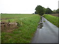
View across fields near Redhouse Farm
This view is from the very narrow lane which eventually reaches High Street Green but first it passes Redhouse Farm. On this miserable October Saturday, it rained from beginning to end.
Image: © Marathon
Taken: 12 Oct 2019
0.16 miles
5
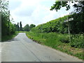
Road Junction
Road junction near to Delvin End, Essex.
Image: © Keith Evans
Taken: 25 May 2017
0.21 miles
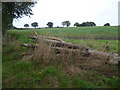
6
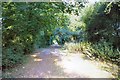
Bridleway to Blois Hall
This final section of the bridleway from Flower's Hall passes through an overhanging wood.
Image: © Bob Jones
Taken: 16 Sep 2007
0.21 miles
7
Lane to Redhouse Farm
This very narrow lane eventually reaches High Street Green but first it passes Redhouse Farm which is in the trees ahead. On this miserable October Saturday, it rained from beginning to end.
Image: © Marathon
Taken: 12 Oct 2019
0.23 miles
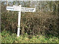
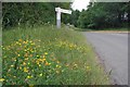
8
Lane to High Street Green
The yellow sign warns of road closure for a day, a few days ahead. There were several such warnings in the district, the highway authority appeared to be about to start a day by day campaign on the surface of the minor lanes.
Image: © Robin Webster
Taken: 17 Apr 2017
0.23 miles
9
Fields near RAF Wethersfield
Looking south from the bridleway between Barr Hall and Flowers Hall.
Image: © Bob Jones
Taken: 16 Sep 2007
0.24 miles
10
Sugar Lane
At the junction with lane to High Street Green. You can take a closer look
at the Image
Image: © Glyn Baker
Taken: 5 Jun 2020
0.24 miles