IMAGES TAKEN NEAR TO
Sudbury Road, HALSTEAD, CO9 3AG
Introduction
This page details the photographs taken nearby to Sudbury Road, CO9 3AG by members of the Geograph project.
The Geograph project started in 2005 with the aim of publishing, organising and preserving representative images for every square kilometre of Great Britain, Ireland and the Isle of Man.

There are currently over 7.5m images from over14,400 individuals and you can help contribute to the project by visiting https://www.geograph.org.uk
Image Map
Images are licensed for reuse under creativecommons.org/licenses/by-sa/2.0
Notes
- Clicking on the map will re-center to the selected point.
- The higher the marker number, the further away the image location is from the centre of the postcode.
Image Listing (7 Images Found)
Images are licensed for reuse under creativecommons.org/licenses/by-sa/2.0
Image
Details
Distance
1
Camille Cottage, B1058, Castle Hedingham
View from the Public Footpath of Camille Cottage the bright pink house just left off centre in the picture.
Image: © Lee Holmes
Taken: 24 Jul 2011
0.04 miles
2
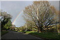
Rainbow over Sudbury Road, Castle Hedingham
Image: © David Howard
Taken: 9 Apr 2024
0.14 miles
3
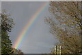
Rainbow over Sudbury Road, Castle Hedingham
Image: © David Howard
Taken: 9 Apr 2024
0.20 miles
4
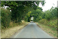
Rosemary Lane
Looking north. It is a through route only by use of the byway part beyond Rushley Green.
Image: © Robin Webster
Taken: 21 Aug 2022
0.21 miles
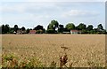
5
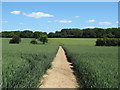
Footpath through wheat field, near Kendallscroft Grove, Castle Hedingham
Image: © Roger Jones
Taken: 7 Jun 2015
0.23 miles
6
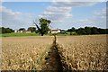
Little Lodge Farm, Castle Hedingham
Public Footpath to Little Lodge Farm and its 16C Barn.
Image: © Lee Holmes
Taken: 24 Jul 2011
0.24 miles
7
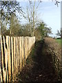
Footpath Looking North
Footpath looking north near to Castle Hedingham, Essex.
Image: © Keith Evans
Taken: 30 Jan 2018
0.24 miles