IMAGES TAKEN NEAR TO
Hedingham Road, HALSTEAD, CO9 2QN
Introduction
This page details the photographs taken nearby to Hedingham Road, CO9 2QN by members of the Geograph project.
The Geograph project started in 2005 with the aim of publishing, organising and preserving representative images for every square kilometre of Great Britain, Ireland and the Isle of Man.

There are currently over 7.5m images from over14,400 individuals and you can help contribute to the project by visiting https://www.geograph.org.uk
Image Map
Images are licensed for reuse under creativecommons.org/licenses/by-sa/2.0
Notes
- Clicking on the map will re-center to the selected point.
- The higher the marker number, the further away the image location is from the centre of the postcode.
Image Listing (8 Images Found)
Images are licensed for reuse under creativecommons.org/licenses/by-sa/2.0
Image
Details
Distance
1
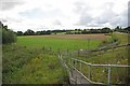
Colne Water Meadow
The road to the right is the A1124 Headingham Rd, The footpath on the other side of the fence is the footpath along the riverbank to Halstead. The field will be submerged if the floodgates of
Image ever need to be closed.
Image: © Glyn Baker
Taken: 27 Aug 2011
0.17 miles
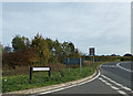
2
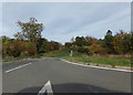
Dynes Hall Road, Whiteash Green
At the junction with the A1124 Hedingham Road at Doe's Corner
Road No.C155
Image: © Geographer
Taken: 13 Oct 2018
0.19 miles
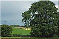
3
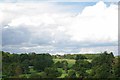
Towards Great Maplestead
Poor waymarking lead to this shot. I was a little confused I was expecting to see a pond but I was way off of the path! However there was a spectacular view across this valley.
Image: © Glyn Baker
Taken: 27 Aug 2011
0.20 miles
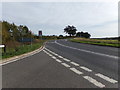
4
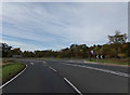
A1124 Hedingham Road, Whiteash Green
At the junction with Dynes Hall Road at Doe's Corner
Image: © Geographer
Taken: 13 Oct 2018
0.20 miles
5
Dynes Hall Road sign
On Dynes Hall Road at the junction with the A1124 Hedingham Road at Doe's Corner
Road No.C155
Image: © Geographer
Taken: 13 Oct 2018
0.21 miles
6
Towards Fitz John's Farm
Looking across Dyne's Hall Rd towards Fitz John's Farm
Image: © Glyn Baker
Taken: 27 Aug 2011
0.21 miles
7
A1124 Hedingham Road, Whiteash Green
At the junction with Dynes Hall Road at Doe's Corner
Image: © Geographer
Taken: 13 Oct 2018
0.23 miles
8
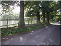
Dyne's hall park boundary
The old park boundary marked by oaks (Elms further up the lane) and a paling fence.
Image: © Simon Leatherdale
Taken: 12 Oct 2006
0.25 miles