IMAGES TAKEN NEAR TO
Lee Close, HALSTEAD, CO9 2GG
Introduction
This page details the photographs taken nearby to Lee Close, CO9 2GG by members of the Geograph project.
The Geograph project started in 2005 with the aim of publishing, organising and preserving representative images for every square kilometre of Great Britain, Ireland and the Isle of Man.

There are currently over 7.5m images from over14,400 individuals and you can help contribute to the project by visiting https://www.geograph.org.uk
Image Map
Images are licensed for reuse under creativecommons.org/licenses/by-sa/2.0
Notes
- Clicking on the map will re-center to the selected point.
- The higher the marker number, the further away the image location is from the centre of the postcode.
Image Listing (6 Images Found)
Images are licensed for reuse under creativecommons.org/licenses/by-sa/2.0
Image
Details
Distance
1
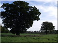
Veteran oak at Star Stile
The veteran trees in this area are a favoured foraging site for bats.
Image: © Simon Leatherdale
Taken: 12 Oct 2006
0.12 miles
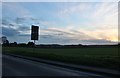
5
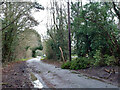
Messy road, Star Stile
After rain and wind.
Image: © Robin Webster
Taken: 24 Dec 2013
0.20 miles
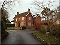
6
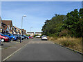
Hawthorn Close, Halstead
On the edge of town, the wood on the right conceals an old gravel pit.
Image: © Robin Webster
Taken: 21 Aug 2022
0.24 miles