IMAGES TAKEN NEAR TO
Woodpecker Close, HALSTEAD, CO9 2FS
Introduction
This page details the photographs taken nearby to Woodpecker Close, CO9 2FS by members of the Geograph project.
The Geograph project started in 2005 with the aim of publishing, organising and preserving representative images for every square kilometre of Great Britain, Ireland and the Isle of Man.

There are currently over 7.5m images from over14,400 individuals and you can help contribute to the project by visiting https://www.geograph.org.uk
Image Map
Images are licensed for reuse under creativecommons.org/licenses/by-sa/2.0
Notes
- Clicking on the map will re-center to the selected point.
- The higher the marker number, the further away the image location is from the centre of the postcode.
Image Listing (21 Images Found)
Images are licensed for reuse under creativecommons.org/licenses/by-sa/2.0
Image
Details
Distance
1
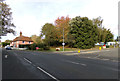
A1124 Colchester Road, Halstead
At the junction with First Avenue
Image: © Geographer
Taken: 13 Oct 2018
0.10 miles
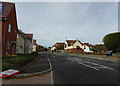
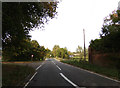
2
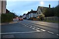
Colchester Road, Halstead
At the corner of Nightingale Drive
Image: © David Howard
Taken: 12 Nov 2023
0.10 miles
3
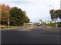
First Avenue, Halstead
At the junction with the A1124 Colchester Road
Image: © Geographer
Taken: 13 Oct 2018
0.11 miles
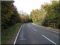
5
A1124 Colchester Road, Halstead
At the junction with Brook Farm Close
Image: © Geographer
Taken: 13 Oct 2018
0.11 miles
6
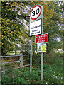
Halstead Town Name sign
On the A1124 Colchester Road at Blue Bridge
Image: © Geographer
Taken: 13 Oct 2018
0.12 miles
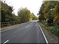
8
Blue Bridge on the A1124 Colchester Road
Image: © Geographer
Taken: 13 Oct 2018
0.17 miles
9
A1124 Colchester Road, Greenstead Green
At the junction with Greenstead Green Road
Image: © Geographer
Taken: 13 Oct 2018
0.19 miles
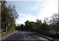
10
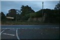
Colchester Road at the end of Church Road
Image: © David Howard
Taken: 12 Nov 2023
0.20 miles