IMAGES TAKEN NEAR TO
Braintree Road, HALSTEAD, CO9 1SL
Introduction
This page details the photographs taken nearby to Braintree Road, CO9 1SL by members of the Geograph project.
The Geograph project started in 2005 with the aim of publishing, organising and preserving representative images for every square kilometre of Great Britain, Ireland and the Isle of Man.

There are currently over 7.5m images from over14,400 individuals and you can help contribute to the project by visiting https://www.geograph.org.uk
Image Map
Images are licensed for reuse under creativecommons.org/licenses/by-sa/2.0
Notes
- Clicking on the map will re-center to the selected point.
- The higher the marker number, the further away the image location is from the centre of the postcode.
Image Listing (5 Images Found)
Images are licensed for reuse under creativecommons.org/licenses/by-sa/2.0
Image
Details
Distance
1
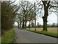
Russell's Road
Its end at the junction with the A131 is ahead.
Image: © Robin Webster
Taken: 19 Mar 2013
0.12 miles
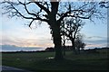
2

Blocked gateway off Russell's Road, Halstead
Image: © Robin Webster
Taken: 19 Mar 2013
0.12 miles
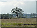
3
Grassland by Bournebridge Hill, Halstead
Image: © David Howard
Taken: 14 Mar 2019
0.20 miles
4
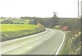
Lay-by on Bournebridge Hill (A131) in 1983
My parents and I were returning from visiting relatives at Image to my house Image from where they returned to their house Image after collecting their dog from a kennels on the way. We had stopped in the lay-by for a lunchtime picnic. My father (George Baker) is seen beside my car, a Renault 4 GTL.
Image: © John Baker
Taken: 19 Oct 1983
0.22 miles