IMAGES TAKEN NEAR TO
Tidings Hill, HALSTEAD, CO9 1BL
Introduction
This page details the photographs taken nearby to Tidings Hill, CO9 1BL by members of the Geograph project.
The Geograph project started in 2005 with the aim of publishing, organising and preserving representative images for every square kilometre of Great Britain, Ireland and the Isle of Man.

There are currently over 7.5m images from over14,400 individuals and you can help contribute to the project by visiting https://www.geograph.org.uk
Image Map
Images are licensed for reuse under creativecommons.org/licenses/by-sa/2.0
Notes
- Clicking on the map will re-center to the selected point.
- The higher the marker number, the further away the image location is from the centre of the postcode.
Image Listing (7 Images Found)
Images are licensed for reuse under creativecommons.org/licenses/by-sa/2.0
Image
Details
Distance
1
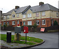
Postbox and houses, Mitchell Avenue
A view of a residential street of Halstead.
Image: © Andrew Hill
Taken: 2 Dec 2009
0.19 miles
2
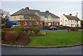
Mitchell Avenue, Halstead
The houses are more modern higher up the street away from the town centre.
Image: © Andrew Hill
Taken: 2 Dec 2009
0.19 miles
3
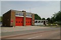
Halstead fire station
Halstead fire station, Parsonage Street, Halstead, Essex
Image: © Kevin Hale
Taken: 5 Jun 2010
0.20 miles
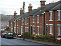
4
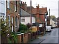
Neale Road, Halstead
A mix of traditional houses along the street, which becomes New Street further along.
Image: © Andrew Hill
Taken: 2 Dec 2009
0.23 miles
5
Mitchell Avenue
The lower end of this residential street. Being closer to town the properties are older at this end.
Image: © Andrew Hill
Taken: 2 Dec 2009
0.24 miles
6
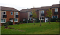
Houses near the post office
The store and houses surround a small grassy area.
Image: © Andrew Hill
Taken: 2 Dec 2009
0.24 miles
7

Looking north along Tidings Hill
The road off to the left, is called White Horse Avenue.
Image: © Robert Edwards
Taken: 27 Apr 2007
0.25 miles