IMAGES TAKEN NEAR TO
Pebmarsh Road, BURES, CO8 5HJ
Introduction
This page details the photographs taken nearby to Pebmarsh Road, CO8 5HJ by members of the Geograph project.
The Geograph project started in 2005 with the aim of publishing, organising and preserving representative images for every square kilometre of Great Britain, Ireland and the Isle of Man.

There are currently over 7.5m images from over14,400 individuals and you can help contribute to the project by visiting https://www.geograph.org.uk
Image Map
Images are licensed for reuse under creativecommons.org/licenses/by-sa/2.0
Notes
- Clicking on the map will re-center to the selected point.
- The higher the marker number, the further away the image location is from the centre of the postcode.
Image Listing (7 Images Found)
Images are licensed for reuse under creativecommons.org/licenses/by-sa/2.0
Image
Details
Distance
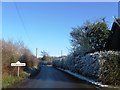
1
Alphamstone Name Sign
Village name sign for Alphamstone, Essex.
Image: © Keith Evans
Taken: 14 Jun 2012
0.03 miles
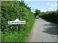
2
Houses on Pebmarsh Road
Looking towards Alphamstone.
Image: © Robin Webster
Taken: 1 Mar 2015
0.04 miles
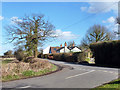
4
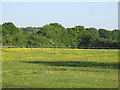
Buttercup pasture, Alphamstone
Buttercups brighten up what looks like a paddock in the parish of Alphamstone.
Image: © Roger Jones
Taken: 18 May 2014
0.16 miles
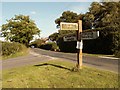
5
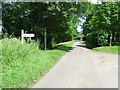
Road Junction
Road junction on Goulds Road leading to Clees Hall near to Alphamstone, Essex.
Image: © Keith Evans
Taken: 14 Jun 2012
0.18 miles
6
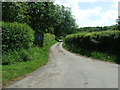
Dead End
Dead-end road off Goulds Road leading to Clees Hall near to Alphamstone, Essex.
Image: © Keith Evans
Taken: 14 Jun 2012
0.18 miles