IMAGES TAKEN NEAR TO
Upper Green, BURES, CO8 5HG
Introduction
This page details the photographs taken nearby to Upper Green, CO8 5HG by members of the Geograph project.
The Geograph project started in 2005 with the aim of publishing, organising and preserving representative images for every square kilometre of Great Britain, Ireland and the Isle of Man.

There are currently over 7.5m images from over14,400 individuals and you can help contribute to the project by visiting https://www.geograph.org.uk
Image Map
Images are licensed for reuse under creativecommons.org/licenses/by-sa/2.0
Notes
- Clicking on the map will re-center to the selected point.
- The higher the marker number, the further away the image location is from the centre of the postcode.
Image Listing (15 Images Found)
Images are licensed for reuse under creativecommons.org/licenses/by-sa/2.0
Image
Details
Distance
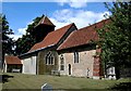
3
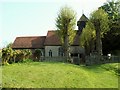
St. Barnabas: the parish church of Alphamstone
This church dates back to the Norman period. Most of the church was restored by Sir Arthur Blomfield in the 19th century.
Image: © Robert Edwards
Taken: 24 Apr 2009
0.11 miles
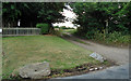
4
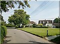
Village scene, Alphamstone, Essex
This picture shows the road to Lamarsh.
Image: © Robert Edwards
Taken: 15 Mar 2006
0.11 miles

7
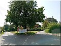
Footpath near Alphamstone church
Entrance to a public footpath, next to Alphamstone church.
Image: © Roger Jones
Taken: 11 Jun 2011
0.13 miles

9

St Barnabas, Alphamstone - Piscina & sedilia
Image: © John Salmon
Taken: 12 Aug 1999
0.13 miles
