IMAGES TAKEN NEAR TO
Alphamstone Back Road, BURES, CO8 5HB
Introduction
This page details the photographs taken nearby to Alphamstone Back Road, CO8 5HB by members of the Geograph project.
The Geograph project started in 2005 with the aim of publishing, organising and preserving representative images for every square kilometre of Great Britain, Ireland and the Isle of Man.

There are currently over 7.5m images from over14,400 individuals and you can help contribute to the project by visiting https://www.geograph.org.uk
Image Map
Images are licensed for reuse under creativecommons.org/licenses/by-sa/2.0
Notes
- Clicking on the map will re-center to the selected point.
- The higher the marker number, the further away the image location is from the centre of the postcode.
Image Listing (5 Images Found)
Images are licensed for reuse under creativecommons.org/licenses/by-sa/2.0
Image
Details
Distance
1
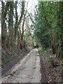
Narrow Road
The minor road named in the map as Henny Back Road near to Alphamstone, Essex.
Image: © Keith Evans
Taken: 8 Mar 2012
0.07 miles
2
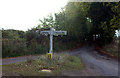
Signpost at Larkin's Lane and Moat Lane junction
The road in the centre leads to Alphamstone
Image: © Robert Eva
Taken: 8 Nov 2016
0.10 miles
3
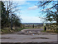
Start of track to Valley Farm
The valley concerned is a quite deeply cut (for Essex) valley draining via Loshes Brook to the River Stour.
Image: © Robin Webster
Taken: 1 Mar 2015
0.12 miles
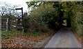
4

Overgrown
Henny Back Road looking south near to Alphamstone, Essex.
Image: © Keith Evans
Taken: 8 Mar 2012
0.17 miles
5
Stour Valley path at Lorkin's Lane
The Stour Valley path/St Edmunds Way meets Lorkin's Lane at this stile.
Image: © Robert Eva
Taken: 8 Nov 2016
0.22 miles