IMAGES TAKEN NEAR TO
Cooks Green Lane, BURES, CO8 5FA
Introduction
This page details the photographs taken nearby to Cooks Green Lane, CO8 5FA by members of the Geograph project.
The Geograph project started in 2005 with the aim of publishing, organising and preserving representative images for every square kilometre of Great Britain, Ireland and the Isle of Man.

There are currently over 7.5m images from over14,400 individuals and you can help contribute to the project by visiting https://www.geograph.org.uk
Image Map (Loading...)


Getting Data...Please wait
Leaflet Map data © OpenStreetMap
Images are licensed for reuse under creativecommons.org/licenses/by-sa/2.0
Notes
- Clicking on the map will re-center to the selected point.
- The higher the marker number, the further away the image location is from the centre of the postcode.
Image Listing (6 Images Found)
Images are licensed for reuse under creativecommons.org/licenses/by-sa/2.0
Image
Details
Distance
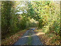
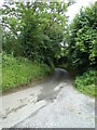
3
Lane towards Lamarsh
Immediately ahead is Shrubs Farm.
Image: © Robin Webster
Taken: 31 Oct 2015
0.21 miles
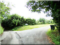
4
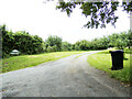
Entrance to Bombase Farm
At the junction with Bombase Lane
Image: © Geographer
Taken: 7 Jul 2021
0.23 miles
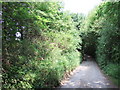
5
Bombose Lane, Bures
At the entrance of Bombose Farm
Image: © Geographer
Taken: 7 Jul 2021
0.23 miles
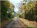
6
Bombose Lane, Bures
At the entrance of Bombose Farm
Image: © Geographer
Taken: 7 Jul 2021
0.23 miles