IMAGES TAKEN NEAR TO
BURES, CO8 5DX
Introduction
This page details the photographs taken nearby to CO8 5DX by members of the Geograph project.
The Geograph project started in 2005 with the aim of publishing, organising and preserving representative images for every square kilometre of Great Britain, Ireland and the Isle of Man.

There are currently over 7.5m images from over14,400 individuals and you can help contribute to the project by visiting https://www.geograph.org.uk
Image Map
Images are licensed for reuse under creativecommons.org/licenses/by-sa/2.0
Notes
- Clicking on the map will re-center to the selected point.
- The higher the marker number, the further away the image location is from the centre of the postcode.
Image Listing (5 Images Found)
Images are licensed for reuse under creativecommons.org/licenses/by-sa/2.0
Image
Details
Distance
1
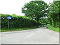
Minor Road
Minor road near to Alphamstone, Essex.
Image: © Keith Evans
Taken: 14 Jun 2012
0.03 miles
3
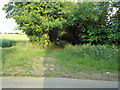
Entrance to tree lined footpath
This path takes you through farmland near Horne's Green, Bures Hamlet.
Image: © Roger Jones
Taken: 11 Jun 2011
0.19 miles
4
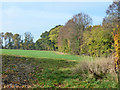
Mature hedgerows near Bures
There are several small woods in this area, connected by hedgerows such as these. Good for wildlife, the experts say.
Image: © Robin Webster
Taken: 31 Oct 2015
0.19 miles
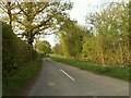
5
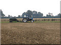
Tractor and new hedge
These flat fields are more than 70 metres above sea level, making them fairly high by Essex standards.
Image: © Peter Wyatt
Taken: 16 Sep 2006
0.21 miles