IMAGES TAKEN NEAR TO
Colne Road, BURES, CO8 5DJ
Introduction
This page details the photographs taken nearby to Colne Road, CO8 5DJ by members of the Geograph project.
The Geograph project started in 2005 with the aim of publishing, organising and preserving representative images for every square kilometre of Great Britain, Ireland and the Isle of Man.

There are currently over 7.5m images from over14,400 individuals and you can help contribute to the project by visiting https://www.geograph.org.uk
Image Map
Images are licensed for reuse under creativecommons.org/licenses/by-sa/2.0
Notes
- Clicking on the map will re-center to the selected point.
- The higher the marker number, the further away the image location is from the centre of the postcode.
Image Listing (4 Images Found)
Images are licensed for reuse under creativecommons.org/licenses/by-sa/2.0
Image
Details
Distance
1
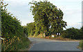
Track to Ferriers, Bures Hamlet
As the road turns east, the track (footpath and bridleway) continues ahead.
Ferriers Barn opened in 1974 as a day centre for young disabled people.
Image: © Roger Jones
Taken: 11 Jun 2011
0.10 miles
2
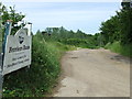
To Ferriers Barn
track leading to Ferriers Barn near to Bures.
Image: © Keith Evans
Taken: 14 Jun 2012
0.12 miles
4
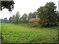
The Ferriers
The barn is disappearing behind brambles and other vegetation. The horse chestnut tree in the top left of the picture has produced a fine crop of 'conkers'.
Image: © Peter Wyatt
Taken: 16 Sep 2006
0.18 miles