IMAGES TAKEN NEAR TO
Colchester Road, BURES, CO8 5AG
Introduction
This page details the photographs taken nearby to Colchester Road, CO8 5AG by members of the Geograph project.
The Geograph project started in 2005 with the aim of publishing, organising and preserving representative images for every square kilometre of Great Britain, Ireland and the Isle of Man.

There are currently over 7.5m images from over14,400 individuals and you can help contribute to the project by visiting https://www.geograph.org.uk
Image Map
Images are licensed for reuse under creativecommons.org/licenses/by-sa/2.0
Notes
- Clicking on the map will re-center to the selected point.
- The higher the marker number, the further away the image location is from the centre of the postcode.
Image Listing (6 Images Found)
Images are licensed for reuse under creativecommons.org/licenses/by-sa/2.0
Image
Details
Distance
1
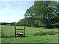
Stile
Stile on the Stour Valley Path near to Bures, Suffolk.
Image: © Keith Evans
Taken: 29 Aug 2013
0.13 miles
2
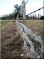
Barbed wire fence
Sheep's wool adorns a field dividing fence in the valley bottom.
Image: © Zorba the Geek
Taken: 8 Feb 2009
0.15 miles
3
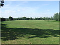
Meadow
Meadow on the south side of the River Stour near to Bures, Suffolk.
Image: © Keith Evans
Taken: 29 Aug 2013
0.17 miles
4
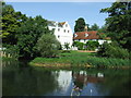
Bures Mill
Bures Mill near to Bures, Suffolk.
Image: © Keith Evans
Taken: 29 Aug 2013
0.19 miles
5

Bures mill from the footpath
Behind the camera is an automatic lock controlling the flow of the passing River Stour.
Image: © Zorba the Geek
Taken: 8 Feb 2009
0.20 miles
6
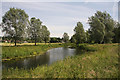
River Stour south of Bures
Looking downstream from the Open Access land on the Essex side of the river.
Image: © Bob Jones
Taken: 24 Jun 2008
0.24 miles