IMAGES TAKEN NEAR TO
Friars Close, COLCHESTER, CO7 9NW
Introduction
This page details the photographs taken nearby to Friars Close, CO7 9NW by members of the Geograph project.
The Geograph project started in 2005 with the aim of publishing, organising and preserving representative images for every square kilometre of Great Britain, Ireland and the Isle of Man.

There are currently over 7.5m images from over14,400 individuals and you can help contribute to the project by visiting https://www.geograph.org.uk
Image Map
Images are licensed for reuse under creativecommons.org/licenses/by-sa/2.0
Notes
- Clicking on the map will re-center to the selected point.
- The higher the marker number, the further away the image location is from the centre of the postcode.
Image Listing (27 Images Found)
Images are licensed for reuse under creativecommons.org/licenses/by-sa/2.0
Image
Details
Distance

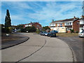
2
Cycle Route 51
Looking along Claremont Road.
Image: © Glyn Baker
Taken: 17 May 2024
0.05 miles
3
Claremont Road, Wivenhoe
Claremont Road in Wivenhoe, Essex.
Image: © Malc McDonald
Taken: 18 Jul 2015
0.07 miles
4

Variegated Ivy
On Ballast Quay Road which can be seen on the right.
Image: © Hamish Griffin
Taken: 26 Sep 2014
0.08 miles

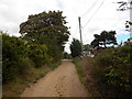
7
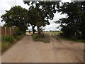
Ballast Quay Road path junction
Ballast Quay Road, the road to the left goes to Bowes Road and Rectory Hill, while the path to the right goes to Alresford Road.
Image: © Hamish Griffin
Taken: 26 Sep 2014
0.08 miles
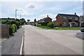
8

Bowes Road, Wivenhoe
Bungalows on Bowes Road, Wivenhoe.
Image: © Malc McDonald
Taken: 18 Jul 2015
0.09 miles
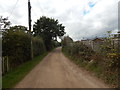
9
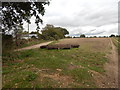
Rollers on field
Ballast Quay Road can be seen on the left.
Image: © Hamish Griffin
Taken: 26 Sep 2014
0.09 miles