IMAGES TAKEN NEAR TO
Ash Grove, COLCHESTER, CO7 9HJ
Introduction
This page details the photographs taken nearby to Ash Grove, CO7 9HJ by members of the Geograph project.
The Geograph project started in 2005 with the aim of publishing, organising and preserving representative images for every square kilometre of Great Britain, Ireland and the Isle of Man.

There are currently over 7.5m images from over14,400 individuals and you can help contribute to the project by visiting https://www.geograph.org.uk
Image Map
Images are licensed for reuse under creativecommons.org/licenses/by-sa/2.0
Notes
- Clicking on the map will re-center to the selected point.
- The higher the marker number, the further away the image location is from the centre of the postcode.
Image Listing (20 Images Found)
Images are licensed for reuse under creativecommons.org/licenses/by-sa/2.0
Image
Details
Distance
2
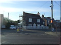
The Flag public house, Wivenhoe
On Colchester Road.
Image: © JThomas
Taken: 27 Apr 2017
0.19 miles
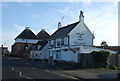
3

The Flag, Wivenhoe
This edge-of-town pub on Colchester Road is owned by the Wellington Pub Company and reports suggest that it has struggled to remain viable in recent years with several changes of landlord and periods of closure. The building dates from the early 19th century and was previously known as the Union Flag.
Image: © Stephen McKay
Taken: 18 Apr 2018
0.19 miles
4
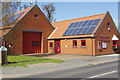
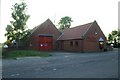
Wivenhoe Fire Station
This compact little fire station on Colchester Road was built in 1990 replacing an earlier station on Brook Street apparently in order to accommodate a larger modern fire engine.
Image: © Stephen McKay
Taken: 18 Apr 2018
0.19 miles
5
Wivenhoe fire station
Wivenhoe fire station, Colchester Road, Wivenhoe, Colchester, Essex, seen from a different angle to Image
Image: © Kevin Hale
Taken: 4 Jun 2010
0.19 miles
6
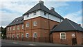
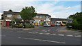
Barley Court
Modern apartments borrowing Essex vernacular.
Image: © David Martin
Taken: 13 May 2015
0.20 miles
7

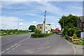
Direction Sign ? Signpost on the B1028 in Wivenhoe
Located on the east side of the B1028 The Cross north of the junction with Rectory Road in Wivenhoe parish. 3 arms and half-moon finial. See also https://www.geograph.org.uk/photo/4188690.
Milestone Society National ID: EX_TM0422
Image: © John V Nicholls
Taken: Unknown
0.21 miles
8

Parish of Wivenhoe sign for Wivenhoe Cross
Slightly to the north of the junction. (C)olchester to the left (3 and a half), Wivenhoe only keeping right at the roundabout, Alresford (3 and a half), Brightlingsea (6 and 3 quarters), St. Osyth (8) and Clacton-on-Sea (12 and 3 quarters). See Image for the roundabout itself, the sign can just be seen behind the roundabout on the left.
Image: © Hamish Griffin
Taken: 26 Sep 2014
0.22 miles
9
Colchester and Elmstead Road Fork
Colchester Road is the left hand fork.
Image: © Glyn Baker
Taken: 17 May 2024
0.22 miles