IMAGES TAKEN NEAR TO
Plough Road, COLCHESTER, CO7 8LZ
Introduction
This page details the photographs taken nearby to Plough Road, CO7 8LZ by members of the Geograph project.
The Geograph project started in 2005 with the aim of publishing, organising and preserving representative images for every square kilometre of Great Britain, Ireland and the Isle of Man.

There are currently over 7.5m images from over14,400 individuals and you can help contribute to the project by visiting https://www.geograph.org.uk
Image Map
Images are licensed for reuse under creativecommons.org/licenses/by-sa/2.0
Notes
- Clicking on the map will re-center to the selected point.
- The higher the marker number, the further away the image location is from the centre of the postcode.
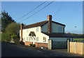
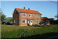
Image Listing (5 Images Found)
Images are licensed for reuse under creativecommons.org/licenses/by-sa/2.0
Image
Details
Distance
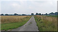
1
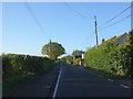
Plough Road, Great Bentley
Looking south east.
Image: © JThomas
Taken: 28 Apr 2017
0.02 miles
4
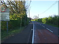
Entering Aingers Green
Looking south east on Plough Road.
Image: © JThomas
Taken: 28 Apr 2017
0.18 miles
5
Track to St Mary's Farm, Great Bentley
Farm track through arable land to St Mary's Farm, Great Bentley.
Image: © Roger Jones
Taken: 25 Aug 2013
0.20 miles