IMAGES TAKEN NEAR TO
Ford Lane, COLCHESTER, CO7 8BE
Introduction
This page details the photographs taken nearby to Ford Lane, CO7 8BE by members of the Geograph project.
The Geograph project started in 2005 with the aim of publishing, organising and preserving representative images for every square kilometre of Great Britain, Ireland and the Isle of Man.

There are currently over 7.5m images from over14,400 individuals and you can help contribute to the project by visiting https://www.geograph.org.uk
Image Map
Images are licensed for reuse under creativecommons.org/licenses/by-sa/2.0
Notes
- Clicking on the map will re-center to the selected point.
- The higher the marker number, the further away the image location is from the centre of the postcode.
Image Listing (24 Images Found)
Images are licensed for reuse under creativecommons.org/licenses/by-sa/2.0
Image
Details
Distance
1
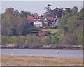
Alresford Grange from across the Colne
The joys of a long lens: a fine house across the river taken from a riverside hide in Fingringhoe Wick nature reserve. Compare Image, a side view.
Image: © Zorba the Geek
Taken: 26 Apr 2009
0.09 miles
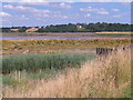
3

Landing stage in Alresford Creek
Two boats are moored at this landing stage, near the entrance to Alresford Creek.
Image: © Bob Jones
Taken: 29 Jan 2009
0.12 miles
4

Landing stage in Alresford Creek
A number of small craft are moored alongside this landing stage in Alresford Creek, a tributary of the River Colne.
Image: © Bob Jones
Taken: 29 Jan 2009
0.13 miles
5

Old boats at Alresford Creek
These boats lie on the north bank of the creek, close to the derelict sand jetty.
Image: © Bob Jones
Taken: 29 Jan 2009
0.13 miles
6

Entrance to Alresford Creek
Looking up the creek from its junction with the River Colne.
Image: © Bob Jones
Taken: 29 Jan 2009
0.14 miles
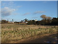

9

Old boathouse and landing stage
Viewed from the entrance to Alresford Creek, with the remains of an old boathouse Image in the foreground and a landing stage Image behind with several boats alongside. In the distance is the Alresford Sand and Gravel site, from where sand used to be delivered to a jetty Image by overhead conveyor.
Image: © Bob Jones
Taken: 29 Jan 2009
0.15 miles
10

Overhead conveyor support pylon
This iron structure once supported an overhead conveyor belt that provided sand from a nearby quarry to the jetty in Alresford Creek.
Image: © Bob Jones
Taken: 29 Jan 2009
0.15 miles