IMAGES TAKEN NEAR TO
Colchester Main Road, COLCHESTER, CO7 8AP
Introduction
This page details the photographs taken nearby to Colchester Main Road, CO7 8AP by members of the Geograph project.
The Geograph project started in 2005 with the aim of publishing, organising and preserving representative images for every square kilometre of Great Britain, Ireland and the Isle of Man.

There are currently over 7.5m images from over14,400 individuals and you can help contribute to the project by visiting https://www.geograph.org.uk
Image Map
Images are licensed for reuse under creativecommons.org/licenses/by-sa/2.0
Notes
- Clicking on the map will re-center to the selected point.
- The higher the marker number, the further away the image location is from the centre of the postcode.
Image Listing (5 Images Found)
Images are licensed for reuse under creativecommons.org/licenses/by-sa/2.0
Image
Details
Distance
1
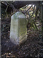
Old Milestone by the B1027, St Osyth Road, Alresford parish
Carved stone post by the B1027, in parish of ALRESFORD (TENDRING District), St Osyth Road, 100m East of junction with Heath Road, on the verge, on South side of road. Erected by an unknown authority in the 19th century.
Inscription reads:-
: 6 MILES / TO / COLCHESTER : : PARISH / OF / ALRESFORD : : 10 MILES / TO / CLACTON / ON SEA :
Grade II listed.
List Entry Number: 1111428 https://historicengland.org.uk/listing/the-list/list-entry/1111428
Milestone Society National ID: EX_CLCO06.
Image: © JV Nicholls
Taken: 26 Feb 2011
0.06 miles
2
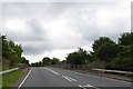
Tenpenny Hill (B1027), Alresford
The B1027 at Alresford, in north Essex.
Image: © Malc McDonald
Taken: 18 Jul 2015
0.12 miles
3
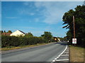
Junction with Withenhoe Road, Alresford
Withenhoe Road marks the southern edge of the village; hence the village signs on the green and the road
Image: © David Smith
Taken: 31 May 2017
0.13 miles
4

Towards the Seaside
This is the Railway line from Colchester to Clacton at Alresford looking towards Clacton
Image: © Glyn Baker
Taken: 9 Apr 2007
0.23 miles