IMAGES TAKEN NEAR TO
Briar Road, COLCHESTER, CO7 7XB
Introduction
This page details the photographs taken nearby to Briar Road, CO7 7XB by members of the Geograph project.
The Geograph project started in 2005 with the aim of publishing, organising and preserving representative images for every square kilometre of Great Britain, Ireland and the Isle of Man.

There are currently over 7.5m images from over14,400 individuals and you can help contribute to the project by visiting https://www.geograph.org.uk
Image Map
Images are licensed for reuse under creativecommons.org/licenses/by-sa/2.0
Notes
- Clicking on the map will re-center to the selected point.
- The higher the marker number, the further away the image location is from the centre of the postcode.
Image Listing (13 Images Found)
Images are licensed for reuse under creativecommons.org/licenses/by-sa/2.0
Image
Details
Distance
5
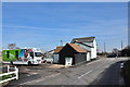
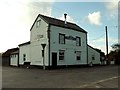
Mobile Library at the cross, Little Bromley
And the pub is a Post Office too!
Image: © MJ Reilly
Taken: 11 Mar 2009
0.18 miles
6
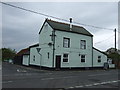
'The Cross Inn' at Bromley Cross, Essex
Image: © Robert Edwards
Taken: 9 Oct 2006
0.21 miles
7
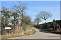
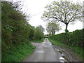
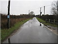
Mill Lane, Little Bromley
The junction of Mill Lane and Hall Lane.
Image: © MJ Reilly
Taken: 11 Mar 2009
0.21 miles