IMAGES TAKEN NEAR TO
Cemetery Lane, COLCHESTER, CO7 6SA
Introduction
This page details the photographs taken nearby to Cemetery Lane, CO7 6SA by members of the Geograph project.
The Geograph project started in 2005 with the aim of publishing, organising and preserving representative images for every square kilometre of Great Britain, Ireland and the Isle of Man.

There are currently over 7.5m images from over14,400 individuals and you can help contribute to the project by visiting https://www.geograph.org.uk
Image Map
Images are licensed for reuse under creativecommons.org/licenses/by-sa/2.0
Notes
- Clicking on the map will re-center to the selected point.
- The higher the marker number, the further away the image location is from the centre of the postcode.
Image Listing (6 Images Found)
Images are licensed for reuse under creativecommons.org/licenses/by-sa/2.0
Image
Details
Distance
1
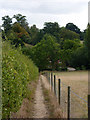
Footpath towards East Bergholt
The path crosses a little dip across a minor tributary of the Stour.
Image: © Andrew Hill
Taken: 10 Sep 2009
0.07 miles
2

Footpath to Stratford St Mary
The footpath from East Bergholt (just past Constable's studio) as it descends to Blind Lane.
Image: © Ron Galliers
Taken: 15 Apr 2007
0.10 miles
3
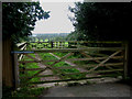
Double gates overlook Dedham Vale
Presumably an arrangement to help corral cattle and sheep, this pair of gates leads out to the slopes of Dedham Vale beyond. Behind is Cemetery Lane.
Image: © Zorba the Geek
Taken: Unknown
0.19 miles
4
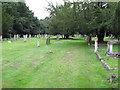
Cemetery Path
Path through East Bergholt cemetery.
Image: © Roger Jones
Taken: 23 Jul 2011
0.20 miles
5
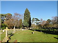
East Bergholt cemetery
The cemetery contains ten First World War War Graves and one from the Second World War. http://media.geograph.org.uk/files/fe9fc289c3ff0af142b6d3bead98a923/East_Bergholt.pdf
Image: © Adrian S Pye
Taken: 4 Dec 2016
0.21 miles
6
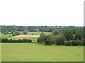
Looking over fields towards Dedham
Taken from footpath, in the background you can see Dedham Church tower.
Note dead tree on field boundary (on right of picture).
Image: © Roger Jones
Taken: 23 Jul 2011
0.23 miles