IMAGES TAKEN NEAR TO
Fiddlers Close, COLCHESTER, CO7 6FD
Introduction
This page details the photographs taken nearby to Fiddlers Close, CO7 6FD by members of the Geograph project.
The Geograph project started in 2005 with the aim of publishing, organising and preserving representative images for every square kilometre of Great Britain, Ireland and the Isle of Man.

There are currently over 7.5m images from over14,400 individuals and you can help contribute to the project by visiting https://www.geograph.org.uk
Image Map
Images are licensed for reuse under creativecommons.org/licenses/by-sa/2.0
Notes
- Clicking on the map will re-center to the selected point.
- The higher the marker number, the further away the image location is from the centre of the postcode.
Image Listing (34 Images Found)
Images are licensed for reuse under creativecommons.org/licenses/by-sa/2.0
Image
Details
Distance
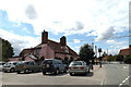
1
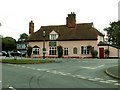
'Carriers Arms' inn, East Bergholt, Suffolk
This inn stands at a junction with the B1070
Image: © Robert Edwards
Taken: 27 Sep 2006
0.09 miles
2
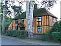
Orange House
Orange timber framed house at East Bergholt, Suffolk.
Image: © Keith Evans
Taken: 3 Nov 2013
0.09 miles
3
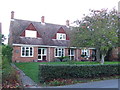
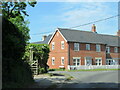
Houses
Houses in Gaston Street East Bergholt, Suffolk the plaque on the left say 'St. John's Houses erected by East Bergholt united charities on land given by Lady Wake-Walker 1964'
Image: © Keith Evans
Taken: 3 Nov 2013
0.10 miles
4
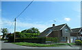
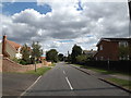
Gaston Street at Chaplin Road East Bergholt
Image: © Roy Hughes
Taken: 14 May 2022
0.12 miles
6
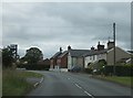
B1070 entering East Bergholt
On the left, Moores Lane suggests an old track. There is no track marked on 19th century and early 20th century maps
Image: © David Smith
Taken: 16 Jun 2014
0.14 miles
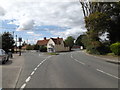
7
The Carriers Inn Public House
On the B1070 Gaston End at the junction with Gaston Street
Image: © Geographer
Taken: 16 Aug 2014
0.18 miles
8
B1070 Gaston End, East Bergholt
At the junction with Gaston Street near The Carriers Inn Public House
Image: © Geographer
Taken: 16 Aug 2014
0.18 miles
9
Elm Road, East Bergholt
At the junction with Hadleigh Road
Image: © Geographer
Taken: 16 Aug 2014
0.18 miles
10
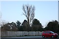
Car park at the Carriers Arms, East Bergholt
The fence has gone up since 2011 and the tall tree in the middle is the only one remaining, the ones on the left were higher but are all now cut down.
Image: © David Howard
Taken: 23 Feb 2019
0.18 miles