IMAGES TAKEN NEAR TO
Monks Lane, COLCHESTER, CO7 6DP
Introduction
This page details the photographs taken nearby to Monks Lane, CO7 6DP by members of the Geograph project.
The Geograph project started in 2005 with the aim of publishing, organising and preserving representative images for every square kilometre of Great Britain, Ireland and the Isle of Man.

There are currently over 7.5m images from over14,400 individuals and you can help contribute to the project by visiting https://www.geograph.org.uk
Image Map
Images are licensed for reuse under creativecommons.org/licenses/by-sa/2.0
Notes
- Clicking on the map will re-center to the selected point.
- The higher the marker number, the further away the image location is from the centre of the postcode.
Image Listing (6 Images Found)
Images are licensed for reuse under creativecommons.org/licenses/by-sa/2.0
Image
Details
Distance
1
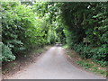
Monks Lane
Leading to a few houses and a farm
Image: © Roger Jones
Taken: 30 Jul 2011
0.08 miles
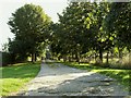
2
Monk's Lane
The lane is classed as a Public Byway.
Image: © Paul Franks
Taken: 8 Nov 2018
0.13 miles
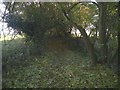
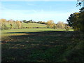
3
Track leading to Monk's Farm, near Dedham, Essex
Image: © Robert Edwards
Taken: 9 Oct 2006
0.14 miles
4
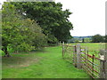
Footpath heading north
Footpath off Coles Oak Lane
Image: © Roger Jones
Taken: 30 Jul 2011
0.16 miles
6
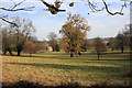
Parkland near Dedham
Looking south towards Freemans Farm from the minor road leading to Rookery Farm.
Image: © Bob Jones
Taken: 19 Nov 2008
0.24 miles