IMAGES TAKEN NEAR TO
Crown Street, COLCHESTER, CO7 6AT
Introduction
This page details the photographs taken nearby to Crown Street, CO7 6AT by members of the Geograph project.
The Geograph project started in 2005 with the aim of publishing, organising and preserving representative images for every square kilometre of Great Britain, Ireland and the Isle of Man.

There are currently over 7.5m images from over14,400 individuals and you can help contribute to the project by visiting https://www.geograph.org.uk
Image Map
Images are licensed for reuse under creativecommons.org/licenses/by-sa/2.0
Notes
- Clicking on the map will re-center to the selected point.
- The higher the marker number, the further away the image location is from the centre of the postcode.
Image Listing (63 Images Found)
Images are licensed for reuse under creativecommons.org/licenses/by-sa/2.0
Image
Details
Distance
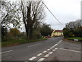
1

Rose and Crown Public House, Dedham
Currently up for sale.
Image: © Paul Shreeve
Taken: 18 Sep 2009
0.08 miles


4
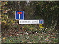
Coopers Lane sign
On Cooper's Lane at the junction with Crown Street & Castle Hill
Image: © Geographer
Taken: 10 Nov 2015
0.14 miles
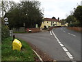
5
Castle Hill, Dedham
At the junction with Cooper's Lane & Crown Street
Image: © Geographer
Taken: 10 Nov 2015
0.14 miles
6

Forge Street sign
On Forge Street at the junction with Crown Street
Image: © Geographer
Taken: 10 Nov 2015
0.15 miles
7
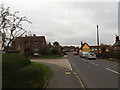
Forge Street, Dedham
At the junction with Crown Street
Image: © Geographer
Taken: 10 Nov 2015
0.15 miles
8
Castle Hill & Castle Hill Postbox
At the junction with East Lane near The Munnings Museum
Postbox No.CO7 94D
Image: © Geographer
Taken: 10 Nov 2015
0.15 miles
9
Crown Street, Dedham
At the junction with Forge Street
Image: © Geographer
Taken: 10 Nov 2015
0.15 miles
10
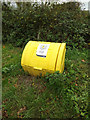
Grit Bin on East Lane
At the junction with Castle Hill
Image: © Geographer
Taken: 10 Nov 2015
0.16 miles