IMAGES TAKEN NEAR TO
Morses Lane, COLCHESTER, CO7 0SF
Introduction
This page details the photographs taken nearby to Morses Lane, CO7 0SF by members of the Geograph project.
The Geograph project started in 2005 with the aim of publishing, organising and preserving representative images for every square kilometre of Great Britain, Ireland and the Isle of Man.

There are currently over 7.5m images from over14,400 individuals and you can help contribute to the project by visiting https://www.geograph.org.uk
Image Map
Images are licensed for reuse under creativecommons.org/licenses/by-sa/2.0
Notes
- Clicking on the map will re-center to the selected point.
- The higher the marker number, the further away the image location is from the centre of the postcode.
Image Listing (3 Images Found)
Images are licensed for reuse under creativecommons.org/licenses/by-sa/2.0
Image
Details
Distance

2
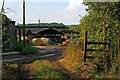
Morses Farm
The footpath from Brightlingsea to Thorrington passes through Morses farm yard.
Image: © Glyn Baker
Taken: 13 Aug 2006
0.22 miles
3
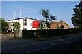
Colne Community School
Colne Community School (nee Colne High) is a foundation College specialising in sporting activities. See also Image
Image: © Glyn Baker
Taken: 13 Aug 2006
0.25 miles