IMAGES TAKEN NEAR TO
Samsons Road, COLCHESTER, CO7 0RL
Introduction
This page details the photographs taken nearby to Samsons Road, CO7 0RL by members of the Geograph project.
The Geograph project started in 2005 with the aim of publishing, organising and preserving representative images for every square kilometre of Great Britain, Ireland and the Isle of Man.

There are currently over 7.5m images from over14,400 individuals and you can help contribute to the project by visiting https://www.geograph.org.uk
Image Map
Images are licensed for reuse under creativecommons.org/licenses/by-sa/2.0
Notes
- Clicking on the map will re-center to the selected point.
- The higher the marker number, the further away the image location is from the centre of the postcode.
Image Listing (6 Images Found)
Images are licensed for reuse under creativecommons.org/licenses/by-sa/2.0
Image
Details
Distance
2

Brightlingsea Village Sign
Brightlingsea village sign Brightlingsea, Essex for overall view see http://www.geograph.org.uk/photo/1431670
Image: © Keith Evans
Taken: 4 Aug 2009
0.17 miles
3
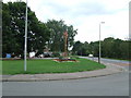
Brightlingsea Village Sign
Brightlingsea village sign Brightlingsea, Essex for close up view see http://www.geograph.org.uk/photo/1431673
Image: © Keith Evans
Taken: 4 Aug 2009
0.18 miles
4
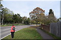
Church Road, Brightlingsea
At Stranger's Corner.
Image: © Trevor Harris
Taken: 4 Nov 2018
0.19 miles
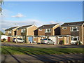
5
Sarre Way
A cul-de-sac towards the northern end of Brightlingsea.
Image: © Trevor Harris
Taken: 4 Nov 2018
0.20 miles
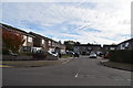
6
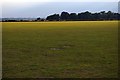
Colne Community School Field
This is one of the playing fields of Image the footpath from Strangers Corner to Image just passes through the North East tip of TM0717 and provides the only public access to it. There is not a lot to see in the playing field during the summer holidays.
Image: © Glyn Baker
Taken: 13 Aug 2006
0.24 miles