IMAGES TAKEN NEAR TO
Marsh Way, COLCHESTER, CO7 0LH
Introduction
This page details the photographs taken nearby to Marsh Way, CO7 0LH by members of the Geograph project.
The Geograph project started in 2005 with the aim of publishing, organising and preserving representative images for every square kilometre of Great Britain, Ireland and the Isle of Man.

There are currently over 7.5m images from over14,400 individuals and you can help contribute to the project by visiting https://www.geograph.org.uk
Image Map
Images are licensed for reuse under creativecommons.org/licenses/by-sa/2.0
Notes
- Clicking on the map will re-center to the selected point.
- The higher the marker number, the further away the image location is from the centre of the postcode.
Image Listing (22 Images Found)
Images are licensed for reuse under creativecommons.org/licenses/by-sa/2.0
Image
Details
Distance
1
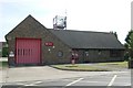
Brightlingsea fire station
Brightlingsea fire station, Lower Park Road, Brightlingsea, Colchester, Essex
Image: © Kevin Hale
Taken: 5 Jun 2010
0.08 miles
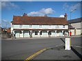
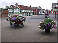
2

Lower Park Road, Brightlingsea
The Railway Tavern opposite uses the National Rail logo on its sign but the station, which was across the road, closed in 1964 and there is no trace of it now.
Image: © Stephen McKay
Taken: 18 Apr 2018
0.12 miles
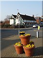
3
The Railway Tavern, Brightlingsea
Brightlingsea has a Railway Tavern on Station Road but sadly no longer has any trains. Nevertheless, the pub has a good reputation for the beer it sells including those brewed in a microbrewery on the premises. The local Campaign for Real Ale branch describes their Crab and Winkle mild as a 'legend'.
Image: © Stephen McKay
Taken: 18 Apr 2018
0.12 miles
4
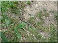
Grass Snake
This snake was around 1.1m Long
Image: © Terry Hamilton
Taken: 3 Aug 2009
0.14 miles
5
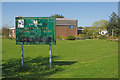
Brightlingsea Community Centre
The community centre is an undistinguished building dating from 1975 but it does incorporate the Liberty Hall which has a capacity for 250 people. Even so, the rather scruffy sign could do with a spruce up. This was the site of Brightlingsea station at the end of a branch from Wivenhoe. The railway was closed in 1964 and the building demolished in 1969. This amateur film from 1963 captures the atmosphere of the line in its dying days: https://player.bfi.org.uk/free/film/watch-river-ride-1963-online
Image: © Stephen McKay
Taken: 18 Apr 2018
0.15 miles
6
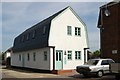
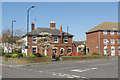
Brightlingsea old fire station
Brightlingsea old fire station, Victoria Place, Brightlingsea, Colchester, Essex, now converted into flats
Image: © Kevin Hale
Taken: 5 Jun 2010
0.15 miles
7
Brightlingsea: The King's Head
The King's Head is at the junction of Queen Street and Ladysmith Avenue (to the left).
It is a Grade II Listed Building and the Historic England website describes it thus:-
"Public House. C16 or earlier origin with later alterations and additions including C19 restorations. Timber framed and rough rendered with batten decoration. Long red plain tiled roof, double range gables to Ladysmith Avenue. Right and 2 rear off centre red brick chimney stacks. 2 storeys. 5 window range of widely spaced vertically sliding sashes with glazing bars and shutters. A red tiled single storey verandah supported by posts with arched braces runs the full length of the building. C19 doors to right, left and centre. Internally much of the frame is covered by C19 boarding, but a C16 brick fireplace, and C16 moulded ceiling and bridging joists are visible."
Image: © Nigel Cox
Taken: 17 Mar 2019
0.17 miles
9
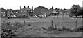
Site of Brightlingsea Station
View NW: completely obliterated site of terminus - buffer stops were to the right, of ex-Great Eastern line from Wivenhoe. The branch had been closed from 2/ to 12/53, after the Great Floods of 31/1/53, but was restored, only to be closed completely on 15/6/64.
Image: © Ben Brooksbank
Taken: 30 May 1983
0.17 miles
10
Victoria Place, Brightlingsea
Taken three years ago on a return trip to the town where we lived for a year in 88-89.
Image: © Calvin Branche
Taken: 3 Sep 2002
0.18 miles