IMAGES TAKEN NEAR TO
Bower House Tye, COLCHESTER, CO6 5DA
Introduction
This page details the photographs taken nearby to Bower House Tye, CO6 5DA by members of the Geograph project.
The Geograph project started in 2005 with the aim of publishing, organising and preserving representative images for every square kilometre of Great Britain, Ireland and the Isle of Man.

There are currently over 7.5m images from over14,400 individuals and you can help contribute to the project by visiting https://www.geograph.org.uk
Image Map
Images are licensed for reuse under creativecommons.org/licenses/by-sa/2.0
Notes
- Clicking on the map will re-center to the selected point.
- The higher the marker number, the further away the image location is from the centre of the postcode.
Image Listing (14 Images Found)
Images are licensed for reuse under creativecommons.org/licenses/by-sa/2.0
Image
Details
Distance
1
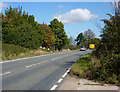
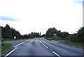
A1071 at Bower House Tye
With traffic heading towards Hadleigh.
Image: © Andrew Hill
Taken: 5 Sep 2009
0.05 miles
2
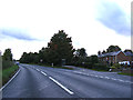
Bower House Tye
At the junction with the A1071 Evan's Heath
Image: © Geographer
Taken: 4 Oct 2013
0.05 miles
4
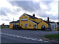
The Brewers Arms Public House, Bower House Tye
Off the A1071 Evan's Heath
Image: © Geographer
Taken: 4 Oct 2013
0.06 miles
5
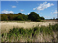
Field and woodland corner
Seen from a path between Bower House Tye and Polstead Heath. The woodland is next to the A1071.
Image: © Andrew Hill
Taken: 5 Sep 2009
0.10 miles


8
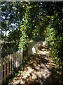
Footpath at Bower House Tye
Near the start of a footpath to Wicker Street Green.
Image: © Andrew Hill
Taken: 5 Sep 2009
0.15 miles
9

Roadsigns on the A1071 Hadleigh Road
At the junction with Holt Road
Image: © Geographer
Taken: 4 Oct 2013
0.17 miles
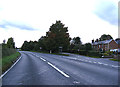
10
A1071 Hadleigh Road, Bower House Tye
At the junction with Holt Road
Image: © Geographer
Taken: 4 Oct 2013
0.17 miles