IMAGES TAKEN NEAR TO
Rockhalls Road, COLCHESTER, CO6 5BF
Introduction
This page details the photographs taken nearby to Rockhalls Road, CO6 5BF by members of the Geograph project.
The Geograph project started in 2005 with the aim of publishing, organising and preserving representative images for every square kilometre of Great Britain, Ireland and the Isle of Man.

There are currently over 7.5m images from over14,400 individuals and you can help contribute to the project by visiting https://www.geograph.org.uk
Image Map
Images are licensed for reuse under creativecommons.org/licenses/by-sa/2.0
Notes
- Clicking on the map will re-center to the selected point.
- The higher the marker number, the further away the image location is from the centre of the postcode.
Image Listing (8 Images Found)
Images are licensed for reuse under creativecommons.org/licenses/by-sa/2.0
Image
Details
Distance
2
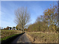
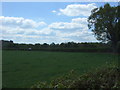
Lane heading west from Shelley Priory Farm
Image: © Robin Webster
Taken: 19 Nov 2017
0.19 miles
8
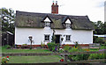
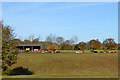
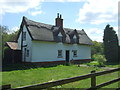
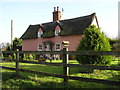
Cottage near Mark Wood
This appears to have been repainted since last photographed by Dave King Image]
Image: © Roger Jones
Taken: 27 Aug 2011
0.25 miles