IMAGES TAKEN NEAR TO
Mill Street, COLCHESTER, CO6 5AD
Introduction
This page details the photographs taken nearby to Mill Street, CO6 5AD by members of the Geograph project.
The Geograph project started in 2005 with the aim of publishing, organising and preserving representative images for every square kilometre of Great Britain, Ireland and the Isle of Man.

There are currently over 7.5m images from over14,400 individuals and you can help contribute to the project by visiting https://www.geograph.org.uk
Image Map (Loading...)


Getting Data...Please wait
Leaflet Map data © OpenStreetMap
Images are licensed for reuse under creativecommons.org/licenses/by-sa/2.0
Notes
- Clicking on the map will re-center to the selected point.
- The higher the marker number, the further away the image location is from the centre of the postcode.
Image Listing (9 Images Found)
Images are licensed for reuse under creativecommons.org/licenses/by-sa/2.0
Image
Details
Distance
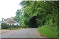
2
Narrow lane in Mill Street
This shows a converted mill in the aptly named community of Mill Street
Image: © Chris Heaton
Taken: 28 Jun 1996
0.12 miles
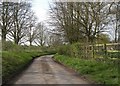
4
Footpath between Mill Street and Marten's Lane, Polstead
Image: © Roger Jones
Taken: 20 Sep 2015
0.14 miles
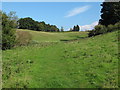
5
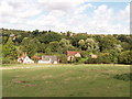
Bell's Corner and Polstead
The houses at the bottom of the field are on Marten's Lane, at Bell's Corner. The houses on the skyline beyond are the village of Polstead.
Image: © David Hawgood
Taken: 3 Sep 2006
0.23 miles
6
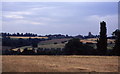
Southern aspect from Bell's Corner
Looks over a field towards some woods. These fall down into the Box Valley, with the distinctive landmark of Stoke-by-Nayland church in the distance on the opposite side
Image: © Chris Heaton
Taken: 28 Jun 1996
0.23 miles
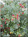
8
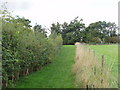
Footpath and hedges, Polstead
The path has been fenced off from the field. Young trees have been planted along the fence, and will eventually form a hedge. The hedge on the left includes wild roses, their fruit shown in Image The tree at the end of the footpath is a sweet chestnut.
Image: © David Hawgood
Taken: 3 Sep 2006
0.23 miles
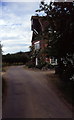
9
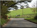
Water Lane at Bell's Corner
As the road turns right it becomes Mill Street and the turning off to the left is Martens Lane.
Image: © Robert Edwards
Taken: 1 Apr 2011
0.25 miles