IMAGES TAKEN NEAR TO
Plough Lane, COLCHESTER, CO6 4PL
Introduction
This page details the photographs taken nearby to Plough Lane, CO6 4PL by members of the Geograph project.
The Geograph project started in 2005 with the aim of publishing, organising and preserving representative images for every square kilometre of Great Britain, Ireland and the Isle of Man.

There are currently over 7.5m images from over14,400 individuals and you can help contribute to the project by visiting https://www.geograph.org.uk
Image Map
Images are licensed for reuse under creativecommons.org/licenses/by-sa/2.0
Notes
- Clicking on the map will re-center to the selected point.
- The higher the marker number, the further away the image location is from the centre of the postcode.
Image Listing (4 Images Found)
Images are licensed for reuse under creativecommons.org/licenses/by-sa/2.0
Image
Details
Distance
2
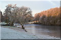
Frozen lake in morning sunlight, Stoke by Nayland Golf Club
Image: © David Martin
Taken: 12 Dec 2012
0.14 miles
3
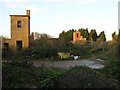
Derelict building at The Carrs near Leavenheath
Image: © Dave King
Taken: 2 Dec 2006
0.15 miles
4
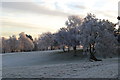
Trees in frost, Stoke by Nayland Golf Club
Image: © David Martin
Taken: 12 Dec 2012
0.21 miles