IMAGES TAKEN NEAR TO
Broad Lane, COLCHESTER, CO6 4HL
Introduction
This page details the photographs taken nearby to Broad Lane, CO6 4HL by members of the Geograph project.
The Geograph project started in 2005 with the aim of publishing, organising and preserving representative images for every square kilometre of Great Britain, Ireland and the Isle of Man.

There are currently over 7.5m images from over14,400 individuals and you can help contribute to the project by visiting https://www.geograph.org.uk
Image Map
Images are licensed for reuse under creativecommons.org/licenses/by-sa/2.0
Notes
- Clicking on the map will re-center to the selected point.
- The higher the marker number, the further away the image location is from the centre of the postcode.
Image Listing (6 Images Found)
Images are licensed for reuse under creativecommons.org/licenses/by-sa/2.0
Image
Details
Distance
1
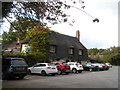
The Yew Tree pub, Great Horkesley
The building dates from the 16th century or earlier and is listed Grade II (as Yew Tree Cottage). See https://historicengland.org.uk/listing/the-list/list-entry/1222982.
Image: © Bikeboy
Taken: 11 Oct 2014
0.12 miles
2
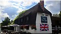
The Yew Tree Public House, Great Horkesley
Image: © PAUL FARMER
Taken: 1 Sep 2015
0.13 miles
3
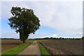
Broad Lane crossing flat North Essex farmland
The Essex Way entering Dedham Vale AONB
Image: © Tim Heaton
Taken: 15 Oct 2020
0.15 miles
4
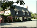
'The Yew Tree' inn, Great Horkesley, Essex
This inn stands alongside the part of the A.134 that was originally a Roman road out of Colchester.
Image: © Robert Edwards
Taken: 11 Sep 2006
0.17 miles
5
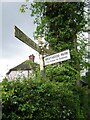
Direction Sign ? Signpost on the A134 in Great Horkesley parish
Located on the east side of the A134 The Causeway and Old House Road in Great Horkesley parish. 3 arms, 1 missing, and lost finial.
Milestone Society National ID: EX_TL9730
Image: © John V Nicholls
Taken: Unknown
0.17 miles
6
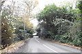
On Old House Road approaching The Causeway (A134)
Image: © Adrian S Pye
Taken: 21 Nov 2019
0.19 miles