IMAGES TAKEN NEAR TO
CO6 4FW
Introduction
This page details the photographs taken nearby to CO6 4FW by members of the Geograph project.
The Geograph project started in 2005 with the aim of publishing, organising and preserving representative images for every square kilometre of Great Britain, Ireland and the Isle of Man.

There are currently over 7.5m images from over14,400 individuals and you can help contribute to the project by visiting https://www.geograph.org.uk
Image Map (Loading...)


Getting Data...Please wait
Leaflet Map data © OpenStreetMap
Images are licensed for reuse under creativecommons.org/licenses/by-sa/2.0
Notes
- Clicking on the map will re-center to the selected point.
- The higher the marker number, the further away the image location is from the centre of the postcode.
Image Listing (22 Images Found)
Images are licensed for reuse under creativecommons.org/licenses/by-sa/2.0
Image
Details
Distance
1
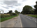
B1068 Sudbury Road, Stoke By Nayland
At the entrance to Steps Farm
Image: © Geographer
Taken: 16 Aug 2014
0.12 miles
2
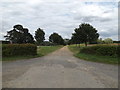
Footpath & entrance to Steps Farm
Off the B1068 Sudbury Road
Image: © Geographer
Taken: 16 Aug 2014
0.12 miles
3
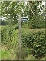
Footpath sign off the B1068 Sudbury Road
At the entrance to Steps Farm
Image: © Geographer
Taken: 16 Aug 2014
0.13 miles
4
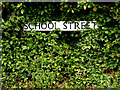
School Street sign
On School Street at the junction with the B1068 Sudbury Road & Polstead Street
Image: © Geographer
Taken: 16 Aug 2014
0.14 miles
5
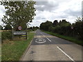
Entering Stoke By Nayland on the B1068 Sudbury Road
Image: © Geographer
Taken: 16 Aug 2014
0.14 miles
6
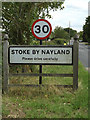
Stoke By Nayland Village Name sign
On the B1068 Sudbury Road
Image: © Geographer
Taken: 16 Aug 2014
0.14 miles
7
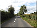
B1068 Sudbury Road, Stoke By Nayland
Looking towards the crossroads near Stoke By Nayland Village Name sign
Image: © Geographer
Taken: 16 Aug 2014
0.15 miles
9
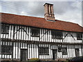
The Old Guildhall in Stoke-by-Nayland
Fantastic chimney. Grade II* listed building - see http://list.english-heritage.org.uk/resultsingle.aspx?uid=1200348
Image: © Eileen Littler
Taken: 21 Apr 2012
0.20 miles
10
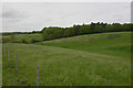
Hilly countryside west of Stoke-by-Nayland
Stoke-by-Nayland is set in quite hilly countryside bordering the valleys of the Stour and Box. The hills to the west seen here are marked on OS maps as The Downs.
Image: © David Kemp
Taken: 20 May 2021
0.20 miles